You are here: Home > Network List > US - United States National Seismic Network Stations List
> Station HAWA Hanford, Washington, USA > Earthquake Result Viewer
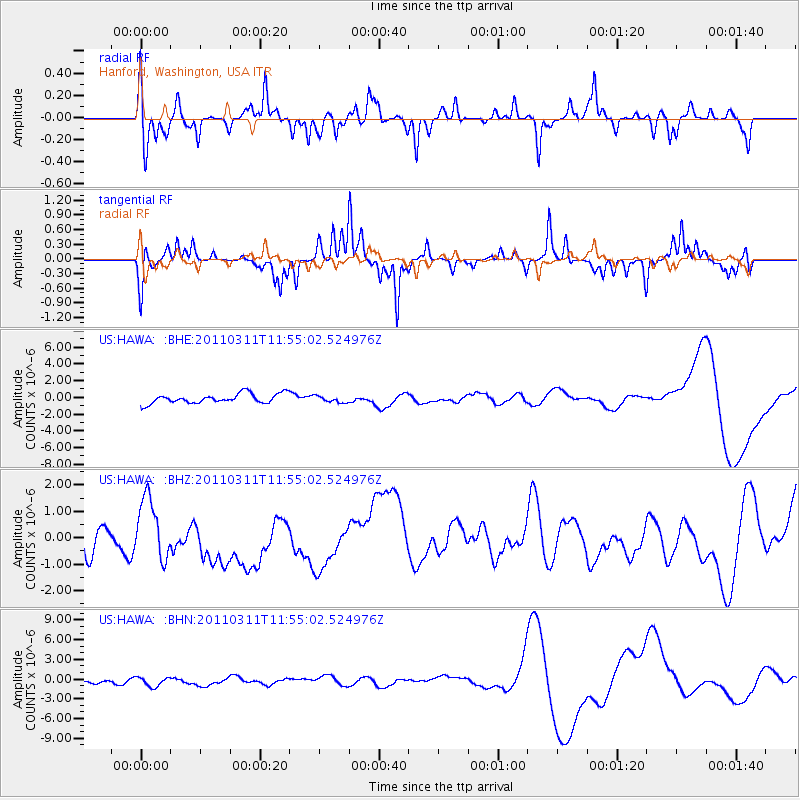
HAWA Hanford, Washington, USA - Earthquake Result Viewer
*The percent match for this event was below the threshold and hence no stack was calculated.
| Earthquake location: |
Off East Coast Of Honshu, Japan |
| Earthquake latitude/longitude: |
36.7/142.2 |
| Earthquake time(UTC): |
2011/03/11 (070) 11:44:28 GMT |
| Earthquake Depth: |
35 km |
| Earthquake Magnitude: |
5.7 MB |
| Earthquake Catalog/Contributor: |
WHDF/NEIC |
|
| Network: |
US United States National Seismic Network |
| Station: |
HAWA Hanford, Washington, USA |
| Lat/Lon: |
46.39 N/119.53 W |
| Elevation: |
364 m |
|
| Distance: |
69.5 deg |
| Az: |
46.99 deg |
| Baz: |
301.881 deg |
| Ray Param: |
$rayparam |
*The percent match for this event was below the threshold and hence was not used in the summary stack. |
|
| Radial Match: |
60.863544 % |
| Radial Bump: |
351 |
| Transverse Match: |
66.62202 % |
| Transverse Bump: |
306 |
| SOD ConfigId: |
356183 |
| Insert Time: |
2011-08-15 16:43:51.217 +0000 |
| GWidth: |
2.5 |
| Max Bumps: |
400 |
| Tol: |
0.001 |
|
Signal To Noise
| Channel | StoN | STA | LTA |
| US:HAWA: :BHZ:20110311T11:55:02.524976Z | 1.4198284 | 1.0423324E-6 | 7.3412565E-7 |
| US:HAWA: :BHN:20110311T11:55:02.524976Z | 1.4349229 | 8.0571704E-7 | 5.6150543E-7 |
| US:HAWA: :BHE:20110311T11:55:02.524976Z | 0.6511286 | 3.785841E-7 | 5.8142757E-7 |
| Arrivals |
| Ps | |
| PpPs | |
| PsPs/PpSs | |


