You are here: Home > Network List > US - United States National Seismic Network Stations List
> Station MNTX Cornudas Mountains, Texas, USA > Earthquake Result Viewer
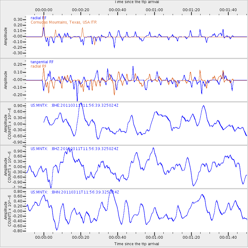
MNTX Cornudas Mountains, Texas, USA - Earthquake Result Viewer
*The percent match for this event was below the threshold and hence no stack was calculated.
| Earthquake location: |
Off East Coast Of Honshu, Japan |
| Earthquake latitude/longitude: |
36.7/142.2 |
| Earthquake time(UTC): |
2011/03/11 (070) 11:44:28 GMT |
| Earthquake Depth: |
35 km |
| Earthquake Magnitude: |
5.7 MB |
| Earthquake Catalog/Contributor: |
WHDF/NEIC |
|
| Network: |
US United States National Seismic Network |
| Station: |
MNTX Cornudas Mountains, Texas, USA |
| Lat/Lon: |
31.70 N/105.38 W |
| Elevation: |
404 m |
|
| Distance: |
87.1 deg |
| Az: |
52.113 deg |
| Baz: |
311.911 deg |
| Ray Param: |
$rayparam |
*The percent match for this event was below the threshold and hence was not used in the summary stack. |
|
| Radial Match: |
55.73968 % |
| Radial Bump: |
235 |
| Transverse Match: |
40.26753 % |
| Transverse Bump: |
311 |
| SOD ConfigId: |
356183 |
| Insert Time: |
2011-08-15 16:45:21.391 +0000 |
| GWidth: |
2.5 |
| Max Bumps: |
400 |
| Tol: |
0.001 |
|
Signal To Noise
| Channel | StoN | STA | LTA |
| US:MNTX: :BHZ:20110311T11:56:39.325024Z | 1.0127015 | 9.1727907E-7 | 9.0577436E-7 |
| US:MNTX: :BHN:20110311T11:56:39.325024Z | 2.3415365 | 3.7552252E-7 | 1.603744E-7 |
| US:MNTX: :BHE:20110311T11:56:39.325024Z | 1.6005145 | 5.68393E-7 | 3.551314E-7 |
| Arrivals |
| Ps | |
| PpPs | |
| PsPs/PpSs | |


