You are here: Home > Network List > CN - Canadian National Seismograph Network Stations List
> Station INK INUVIK, NT, CANADA.ANADA > Earthquake Result Viewer
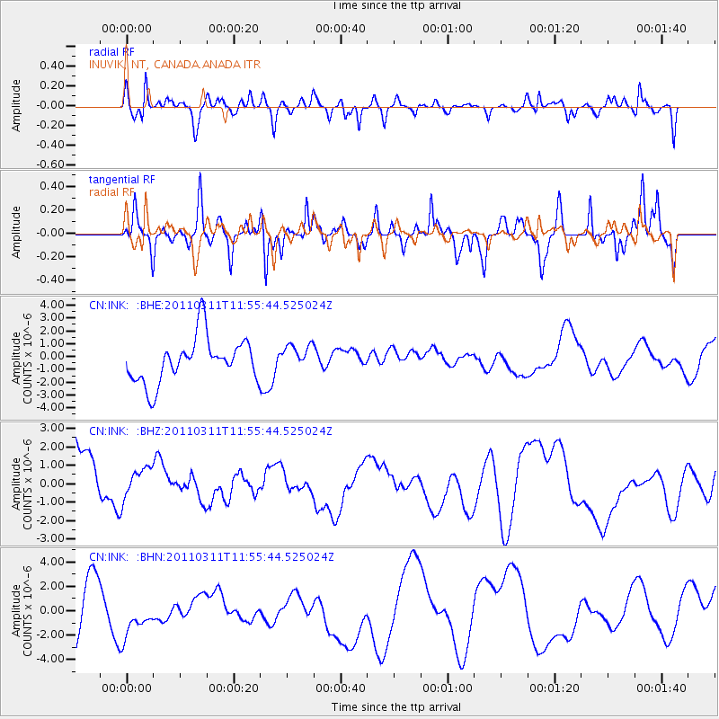
INK INUVIK, NT, CANADA.ANADA - Earthquake Result Viewer
*The percent match for this event was below the threshold and hence no stack was calculated.
| Earthquake location: |
Near East Coast Of Honshu, Japan |
| Earthquake latitude/longitude: |
36.0/141.2 |
| Earthquake time(UTC): |
2011/03/11 (070) 11:46:42 GMT |
| Earthquake Depth: |
18 km |
| Earthquake Magnitude: |
5.8 MB |
| Earthquake Catalog/Contributor: |
WHDF/NEIC |
|
| Network: |
CN Canadian National Seismograph Network |
| Station: |
INK INUVIK, NT, CANADA.ANADA |
| Lat/Lon: |
68.31 N/133.52 W |
| Elevation: |
40 m |
|
| Distance: |
55.4 deg |
| Az: |
26.757 deg |
| Baz: |
280.928 deg |
| Ray Param: |
$rayparam |
*The percent match for this event was below the threshold and hence was not used in the summary stack. |
|
| Radial Match: |
60.686714 % |
| Radial Bump: |
393 |
| Transverse Match: |
54.389862 % |
| Transverse Bump: |
288 |
| SOD ConfigId: |
356183 |
| Insert Time: |
2011-08-15 17:30:41.163 +0000 |
| GWidth: |
2.5 |
| Max Bumps: |
400 |
| Tol: |
0.001 |
|
Signal To Noise
| Channel | StoN | STA | LTA |
| CN:INK: :BHZ:20110311T11:55:44.525024Z | 0.59501344 | 1.1495413E-6 | 1.9319584E-6 |
| CN:INK: :BHN:20110311T11:55:44.525024Z | 0.54508644 | 1.7155967E-6 | 3.1473846E-6 |
| CN:INK: :BHE:20110311T11:55:44.525024Z | 0.57818 | 1.0125273E-6 | 1.7512319E-6 |
| Arrivals |
| Ps | |
| PpPs | |
| PsPs/PpSs | |


