You are here: Home > Network List > XG92 - Rocky Mountain Front Stations List
> Station WIG Orchard, CO > Earthquake Result Viewer
WIG Orchard, CO - Earthquake Result Viewer
| Earthquake location: |
Northern Peru |
| Earthquake latitude/longitude: |
-3.9/-76.6 |
| Earthquake time(UTC): |
1992/07/13 (195) 18:11:34 GMT |
| Earthquake Depth: |
100 km |
| Earthquake Magnitude: |
6.2 MB |
| Earthquake Catalog/Contributor: |
WHDF/NEIC |
|
| Network: |
XG Rocky Mountain Front |
| Station: |
WIG Orchard, CO |
| Lat/Lon: |
40.33 N/104.07 W |
| Elevation: |
1368 m |
|
| Distance: |
50.7 deg |
| Az: |
332.922 deg |
| Baz: |
143.555 deg |
| Ray Param: |
0.06755251 |
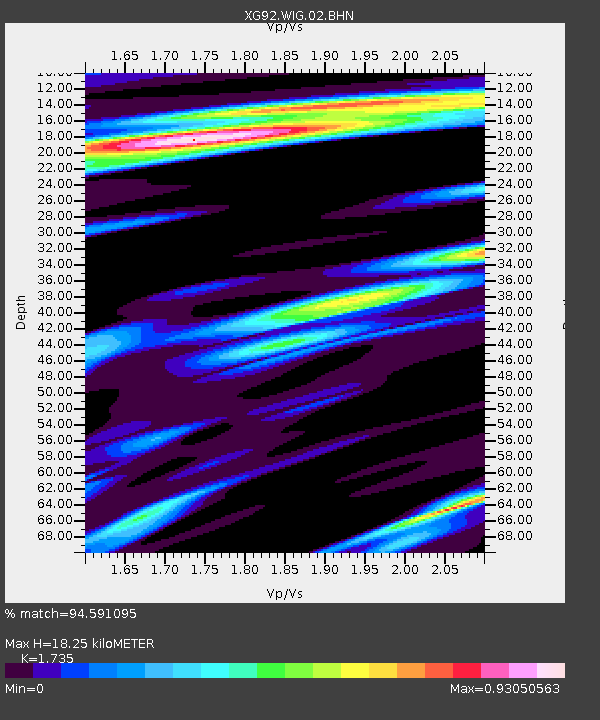
| Estimated Moho Depth: |
18.25 km |
| Estimated Crust Vp/Vs: |
1.74 |
| Assumed Crust Vp: |
6.306 km/s |
| Estimated Crust Vs: |
3.635 km/s |
| Estimated Crust Poisson's Ratio: |
0.25 |
|
| Radial Match: |
94.591095 % |
| Radial Bump: |
400 |
| Transverse Match: |
85.44091 % |
| Transverse Bump: |
400 |
| SOD ConfigId: |
3286 |
| Insert Time: |
2010-02-25 20:12:04.025 +0000 |
| GWidth: |
2.5 |
| Max Bumps: |
400 |
| Tol: |
0.001 |
|
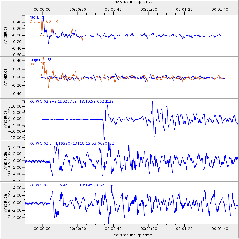
Signal To Noise
| Channel | StoN | STA | LTA |
| XG:WIG:02:BHN:19920713T18:19:53.062012Z | 2.4610739 | 4.4549233E-4 | 1.8101542E-4 |
| XG:WIG:02:BHE:19920713T18:19:53.062012Z | 2.3331656 | 3.4199152E-4 | 1.4657834E-4 |
| XG:WIG:02:BHZ:19920713T18:19:53.062012Z | 29.845291 | 0.0029454369 | 9.869017E-5 |
| Arrivals |
| Ps | 2.2 SECOND |
| PpPs | 7.5 SECOND |
| PsPs/PpSs | 9.7 SECOND |


