You are here: Home > Network List > TA - USArray Transportable Network (new EarthScope stations) Stations List
> Station M31A Lambtecht Ranch, Loup City, NE, USA > Earthquake Result Viewer
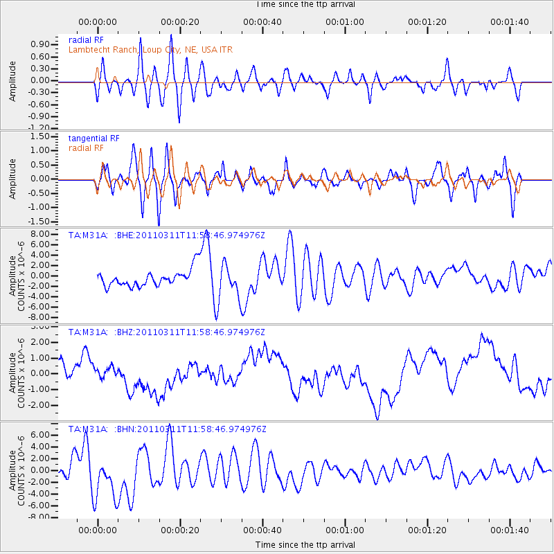
M31A Lambtecht Ranch, Loup City, NE, USA - Earthquake Result Viewer
*The percent match for this event was below the threshold and hence no stack was calculated.
| Earthquake location: |
Near East Coast Of Honshu, Japan |
| Earthquake latitude/longitude: |
36.0/141.2 |
| Earthquake time(UTC): |
2011/03/11 (070) 11:46:42 GMT |
| Earthquake Depth: |
18 km |
| Earthquake Magnitude: |
5.8 MB |
| Earthquake Catalog/Contributor: |
WHDF/NEIC |
|
| Network: |
TA USArray Transportable Network (new EarthScope stations) |
| Station: |
M31A Lambtecht Ranch, Loup City, NE, USA |
| Lat/Lon: |
41.34 N/98.98 W |
| Elevation: |
699 m |
|
| Distance: |
85.3 deg |
| Az: |
40.936 deg |
| Baz: |
315.123 deg |
| Ray Param: |
$rayparam |
*The percent match for this event was below the threshold and hence was not used in the summary stack. |
|
| Radial Match: |
50.002872 % |
| Radial Bump: |
400 |
| Transverse Match: |
46.151497 % |
| Transverse Bump: |
400 |
| SOD ConfigId: |
356183 |
| Insert Time: |
2011-08-15 18:24:21.760 +0000 |
| GWidth: |
2.5 |
| Max Bumps: |
400 |
| Tol: |
0.001 |
|
Signal To Noise
| Channel | StoN | STA | LTA |
| TA:M31A: :BHZ:20110311T11:58:46.974976Z | 0.6265696 | 3.2471584E-7 | 5.1824384E-7 |
| TA:M31A: :BHN:20110311T11:58:46.974976Z | 3.1810484 | 3.961108E-6 | 1.2452209E-6 |
| TA:M31A: :BHE:20110311T11:58:46.974976Z | 2.0810888 | 3.3803342E-6 | 1.6243105E-6 |
| Arrivals |
| Ps | |
| PpPs | |
| PsPs/PpSs | |


