You are here: Home > Network List > XG92 - Rocky Mountain Front Stations List
> Station WIG Orchard, CO > Earthquake Result Viewer
WIG Orchard, CO - Earthquake Result Viewer
| Earthquake location: |
Near East Coast Of Kamchatka |
| Earthquake latitude/longitude: |
51.2/157.7 |
| Earthquake time(UTC): |
1992/07/13 (195) 15:34:05 GMT |
| Earthquake Depth: |
53 km |
| Earthquake Magnitude: |
5.7 MB |
| Earthquake Catalog/Contributor: |
WHDF/NEIC |
|
| Network: |
XG Rocky Mountain Front |
| Station: |
WIG Orchard, CO |
| Lat/Lon: |
40.33 N/104.07 W |
| Elevation: |
1368 m |
|
| Distance: |
64.4 deg |
| Az: |
57.006 deg |
| Baz: |
316.303 deg |
| Ray Param: |
0.058813926 |
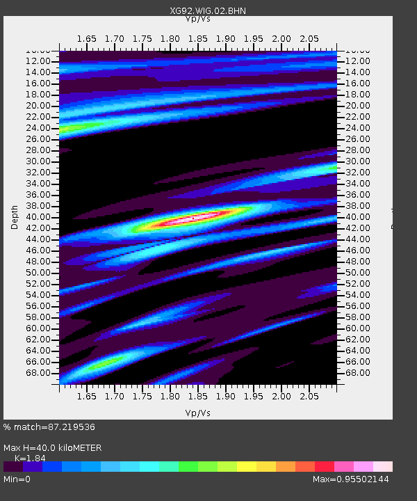
| Estimated Moho Depth: |
40.0 km |
| Estimated Crust Vp/Vs: |
1.84 |
| Assumed Crust Vp: |
6.306 km/s |
| Estimated Crust Vs: |
3.427 km/s |
| Estimated Crust Poisson's Ratio: |
0.29 |
|
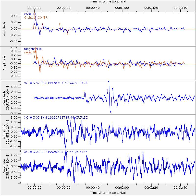
| Radial Match: |
87.219536 % |
| Radial Bump: |
400 |
| Transverse Match: |
79.698845 % |
| Transverse Bump: |
400 |
| SOD ConfigId: |
3286 |
| Insert Time: |
2010-02-25 20:12:05.574 +0000 |
| GWidth: |
2.5 |
| Max Bumps: |
400 |
| Tol: |
0.001 |
|
Signal To Noise
| Channel | StoN | STA | LTA |
| XG:WIG:02:BHN:19920713T15:44:05.513Z | 1.1848388 | 2.4588648E-4 | 2.0752737E-4 |
| XG:WIG:02:BHE:19920713T15:44:05.513Z | 1.0721946 | 1.8578953E-4 | 1.7327967E-4 |
| XG:WIG:02:BHZ:19920713T15:44:05.513Z | 6.90867 | 7.2376477E-4 | 1.0476181E-4 |
| Arrivals |
| Ps | 5.5 SECOND |
| PpPs | 17 SECOND |
| PsPs/PpSs | 23 SECOND |


