You are here: Home > Network List > AZ - ANZA Regional Network Stations List
> Station MONP2 Monument Peak TA Vault, Anza, CA, USA > Earthquake Result Viewer
MONP2 Monument Peak TA Vault, Anza, CA, USA - Earthquake Result Viewer

| Earthquake location: |
Kuril Islands |
| Earthquake latitude/longitude: |
46.0/151.4 |
| Earthquake time(UTC): |
2009/04/18 (108) 19:17:58 GMT |
| Earthquake Depth: |
35 km |
| Earthquake Magnitude: |
6.3 MB, 6.3 MS, 6.6 MW, 6.4 MW |
| Earthquake Catalog/Contributor: |
WHDF/NEIC |
|
| Network: |
AZ ANZA Regional Network |
| Station: |
MONP2 Monument Peak TA Vault, Anza, CA, USA |
| Lat/Lon: |
32.89 N/116.42 W |
| Elevation: |
1000 m |
|
| Distance: |
68.6 deg |
| Az: |
64.596 deg |
| Baz: |
311.566 deg |
| Ray Param: |
0.0561727 |
| Estimated Moho Depth: |
30.5 km |
| Estimated Crust Vp/Vs: |
1.85 |
| Assumed Crust Vp: |
6.264 km/s |
| Estimated Crust Vs: |
3.386 km/s |
| Estimated Crust Poisson's Ratio: |
0.29 |
|
| Radial Match: |
85.62022 % |
| Radial Bump: |
400 |
| Transverse Match: |
74.51126 % |
| Transverse Bump: |
400 |
| SOD ConfigId: |
2760 |
| Insert Time: |
2010-02-26 20:02:23.892 +0000 |
| GWidth: |
2.5 |
| Max Bumps: |
400 |
| Tol: |
0.001 |
|
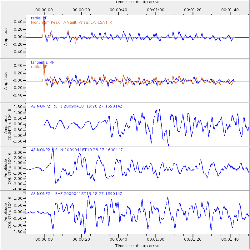
Signal To Noise
| Channel | StoN | STA | LTA |
| AZ:MONP2: :BHN:20090418T19:28:27.169014Z | 12.957053 | 1.5030314E-6 | 1.1600102E-7 |
| AZ:MONP2: :BHE:20090418T19:28:27.169014Z | 2.855671 | 4.178435E-7 | 1.463206E-7 |
| AZ:MONP2: :BHZ:20090418T19:28:27.169014Z | 1.3838732 | 3.3133173E-7 | 2.3942346E-7 |
| Arrivals |
| Ps | 4.3 SECOND |
| PpPs | 13 SECOND |
| PsPs/PpSs | 18 SECOND |


