You are here: Home > Network List > TA - USArray Transportable Network (new EarthScope stations) Stations List
> Station Z35A Perchaven, Sanger, TX, USA > Earthquake Result Viewer
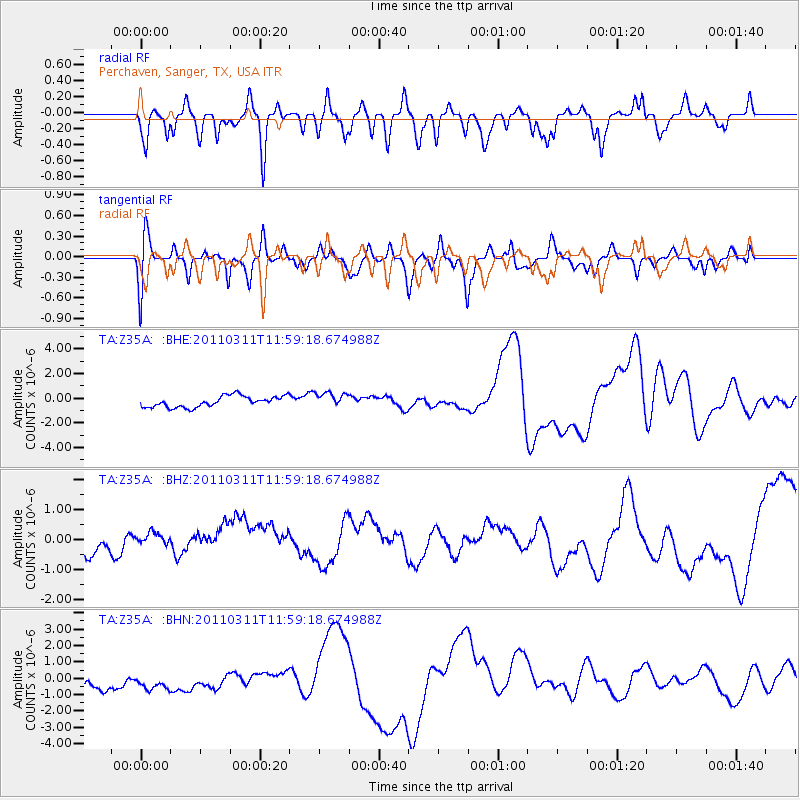
Z35A Perchaven, Sanger, TX, USA - Earthquake Result Viewer
*The percent match for this event was below the threshold and hence no stack was calculated.
| Earthquake location: |
Near East Coast Of Honshu, Japan |
| Earthquake latitude/longitude: |
36.0/141.2 |
| Earthquake time(UTC): |
2011/03/11 (070) 11:46:42 GMT |
| Earthquake Depth: |
18 km |
| Earthquake Magnitude: |
5.8 MB |
| Earthquake Catalog/Contributor: |
WHDF/NEIC |
|
| Network: |
TA USArray Transportable Network (new EarthScope stations) |
| Station: |
Z35A Perchaven, Sanger, TX, USA |
| Lat/Lon: |
33.33 N/97.25 W |
| Elevation: |
235 m |
|
| Distance: |
92.0 deg |
| Az: |
45.536 deg |
| Baz: |
316.272 deg |
| Ray Param: |
$rayparam |
*The percent match for this event was below the threshold and hence was not used in the summary stack. |
|
| Radial Match: |
43.619297 % |
| Radial Bump: |
400 |
| Transverse Match: |
21.408224 % |
| Transverse Bump: |
400 |
| SOD ConfigId: |
356183 |
| Insert Time: |
2011-08-15 18:34:13.845 +0000 |
| GWidth: |
2.5 |
| Max Bumps: |
400 |
| Tol: |
0.001 |
|
Signal To Noise
| Channel | StoN | STA | LTA |
| TA:Z35A: :BHZ:20110311T11:59:18.674988Z | 0.5756418 | 3.4321684E-7 | 5.9623335E-7 |
| TA:Z35A: :BHN:20110311T11:59:18.674988Z | 1.1997087 | 1.1982804E-6 | 9.988095E-7 |
| TA:Z35A: :BHE:20110311T11:59:18.674988Z | 1.3352807 | 6.014767E-7 | 4.5044965E-7 |
| Arrivals |
| Ps | |
| PpPs | |
| PsPs/PpSs | |


