You are here: Home > Network List > TA - USArray Transportable Network (new EarthScope stations) Stations List
> Station 234A Clairette, TX, USA > Earthquake Result Viewer
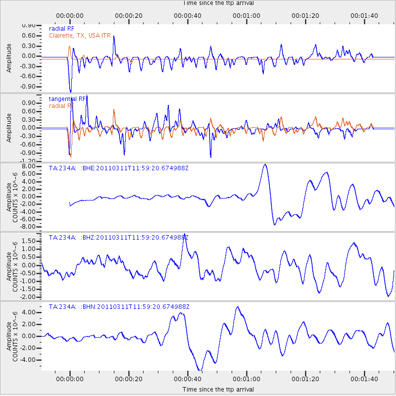
234A Clairette, TX, USA - Earthquake Result Viewer
*The percent match for this event was below the threshold and hence no stack was calculated.
| Earthquake location: |
Near East Coast Of Honshu, Japan |
| Earthquake latitude/longitude: |
36.0/141.2 |
| Earthquake time(UTC): |
2011/03/11 (070) 11:46:42 GMT |
| Earthquake Depth: |
18 km |
| Earthquake Magnitude: |
5.8 MB |
| Earthquake Catalog/Contributor: |
WHDF/NEIC |
|
| Network: |
TA USArray Transportable Network (new EarthScope stations) |
| Station: |
234A Clairette, TX, USA |
| Lat/Lon: |
32.00 N/98.14 W |
| Elevation: |
358 m |
|
| Distance: |
92.5 deg |
| Az: |
46.993 deg |
| Baz: |
315.74 deg |
| Ray Param: |
$rayparam |
*The percent match for this event was below the threshold and hence was not used in the summary stack. |
|
| Radial Match: |
42.243977 % |
| Radial Bump: |
371 |
| Transverse Match: |
40.990932 % |
| Transverse Bump: |
349 |
| SOD ConfigId: |
356183 |
| Insert Time: |
2011-08-15 18:35:55.137 +0000 |
| GWidth: |
2.5 |
| Max Bumps: |
400 |
| Tol: |
0.001 |
|
Signal To Noise
| Channel | StoN | STA | LTA |
| TA:234A: :BHZ:20110311T11:59:20.674988Z | 1.1957871 | 4.2620653E-7 | 3.564234E-7 |
| TA:234A: :BHN:20110311T11:59:20.674988Z | 1.2553812 | 1.0140502E-6 | 8.077628E-7 |
| TA:234A: :BHE:20110311T11:59:20.674988Z | 1.3033048 | 7.964657E-7 | 6.111124E-7 |
| Arrivals |
| Ps | |
| PpPs | |
| PsPs/PpSs | |


