You are here: Home > Network List > TA - USArray Transportable Network (new EarthScope stations) Stations List
> Station Y35A Marietta, OK, USA > Earthquake Result Viewer
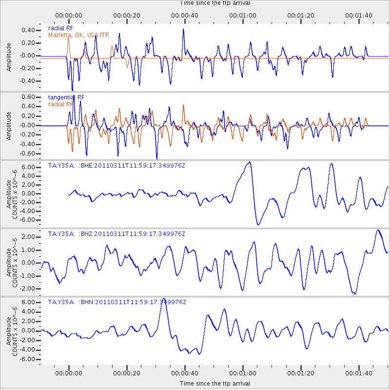
Y35A Marietta, OK, USA - Earthquake Result Viewer
*The percent match for this event was below the threshold and hence no stack was calculated.
| Earthquake location: |
Near East Coast Of Honshu, Japan |
| Earthquake latitude/longitude: |
36.0/141.2 |
| Earthquake time(UTC): |
2011/03/11 (070) 11:46:42 GMT |
| Earthquake Depth: |
18 km |
| Earthquake Magnitude: |
5.8 MB |
| Earthquake Catalog/Contributor: |
WHDF/NEIC |
|
| Network: |
TA USArray Transportable Network (new EarthScope stations) |
| Station: |
Y35A Marietta, OK, USA |
| Lat/Lon: |
33.91 N/97.04 W |
| Elevation: |
214 m |
|
| Distance: |
91.7 deg |
| Az: |
45.01 deg |
| Baz: |
316.408 deg |
| Ray Param: |
$rayparam |
*The percent match for this event was below the threshold and hence was not used in the summary stack. |
|
| Radial Match: |
37.089306 % |
| Radial Bump: |
302 |
| Transverse Match: |
29.502003 % |
| Transverse Bump: |
236 |
| SOD ConfigId: |
356183 |
| Insert Time: |
2011-08-15 18:44:37.116 +0000 |
| GWidth: |
2.5 |
| Max Bumps: |
400 |
| Tol: |
0.001 |
|
Signal To Noise
| Channel | StoN | STA | LTA |
| TA:Y35A: :BHZ:20110311T11:59:17.349976Z | 1.1767007 | 4.7561602E-7 | 4.0419457E-7 |
| TA:Y35A: :BHN:20110311T11:59:17.349976Z | 1.7323056 | 1.7827336E-6 | 1.0291103E-6 |
| TA:Y35A: :BHE:20110311T11:59:17.349976Z | 0.68532103 | 3.57723E-7 | 5.2197873E-7 |
| Arrivals |
| Ps | |
| PpPs | |
| PsPs/PpSs | |


