You are here: Home > Network List > TA - USArray Transportable Network (new EarthScope stations) Stations List
> Station T36A Boggs Farm, Caney, KS, USA > Earthquake Result Viewer
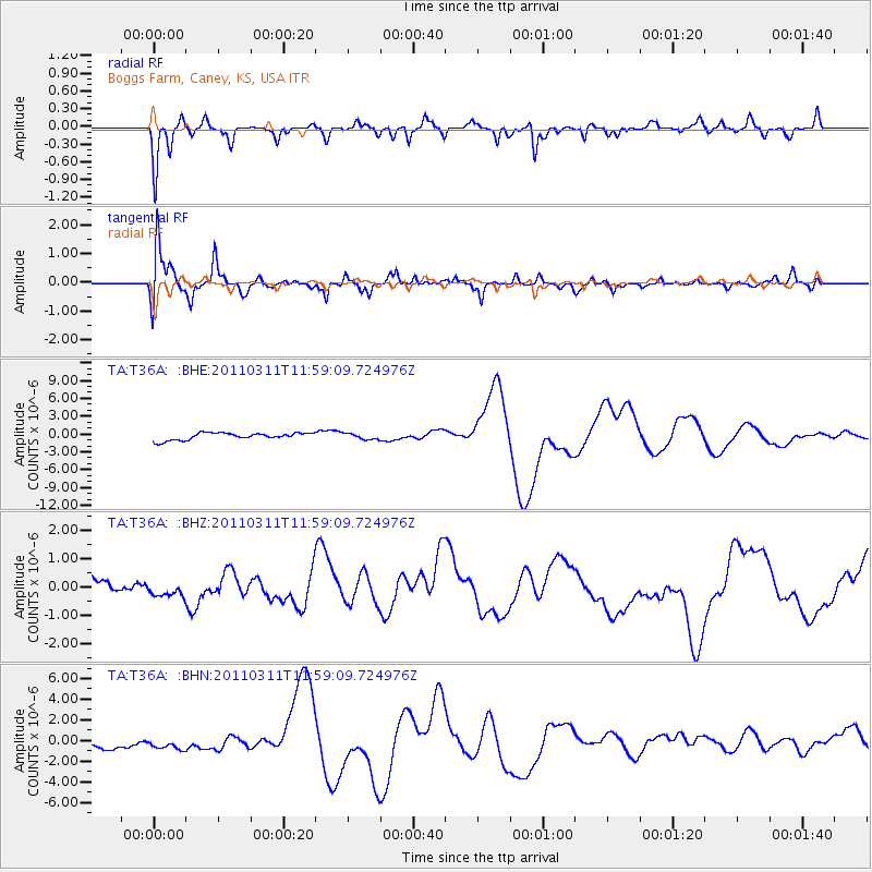
T36A Boggs Farm, Caney, KS, USA - Earthquake Result Viewer
*The percent match for this event was below the threshold and hence no stack was calculated.
| Earthquake location: |
Near East Coast Of Honshu, Japan |
| Earthquake latitude/longitude: |
36.0/141.2 |
| Earthquake time(UTC): |
2011/03/11 (070) 11:46:42 GMT |
| Earthquake Depth: |
18 km |
| Earthquake Magnitude: |
5.8 MB |
| Earthquake Catalog/Contributor: |
WHDF/NEIC |
|
| Network: |
TA USArray Transportable Network (new EarthScope stations) |
| Station: |
T36A Boggs Farm, Caney, KS, USA |
| Lat/Lon: |
37.06 N/95.88 W |
| Elevation: |
243 m |
|
| Distance: |
90.1 deg |
| Az: |
42.165 deg |
| Baz: |
317.124 deg |
| Ray Param: |
$rayparam |
*The percent match for this event was below the threshold and hence was not used in the summary stack. |
|
| Radial Match: |
46.856228 % |
| Radial Bump: |
264 |
| Transverse Match: |
28.8759 % |
| Transverse Bump: |
341 |
| SOD ConfigId: |
356183 |
| Insert Time: |
2011-08-15 18:45:45.410 +0000 |
| GWidth: |
2.5 |
| Max Bumps: |
400 |
| Tol: |
0.001 |
|
Signal To Noise
| Channel | StoN | STA | LTA |
| TA:T36A: :BHZ:20110311T11:59:09.724976Z | 0.6902213 | 2.1941923E-7 | 3.1789693E-7 |
| TA:T36A: :BHN:20110311T11:59:09.724976Z | 1.0832348 | 9.271798E-7 | 8.559361E-7 |
| TA:T36A: :BHE:20110311T11:59:09.724976Z | 0.8443609 | 5.032422E-7 | 5.9600364E-7 |
| Arrivals |
| Ps | |
| PpPs | |
| PsPs/PpSs | |


