You are here: Home > Network List > TA - USArray Transportable Network (new EarthScope stations) Stations List
> Station 136A Ennis, TX, USA > Earthquake Result Viewer
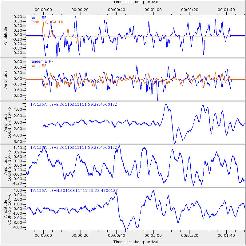
136A Ennis, TX, USA - Earthquake Result Viewer
*The percent match for this event was below the threshold and hence no stack was calculated.
| Earthquake location: |
Near East Coast Of Honshu, Japan |
| Earthquake latitude/longitude: |
36.0/141.2 |
| Earthquake time(UTC): |
2011/03/11 (070) 11:46:42 GMT |
| Earthquake Depth: |
18 km |
| Earthquake Magnitude: |
5.8 MB |
| Earthquake Catalog/Contributor: |
WHDF/NEIC |
|
| Network: |
TA USArray Transportable Network (new EarthScope stations) |
| Station: |
136A Ennis, TX, USA |
| Lat/Lon: |
32.47 N/96.53 W |
| Elevation: |
113 m |
|
| Distance: |
93.1 deg |
| Az: |
45.684 deg |
| Baz: |
316.657 deg |
| Ray Param: |
$rayparam |
*The percent match for this event was below the threshold and hence was not used in the summary stack. |
|
| Radial Match: |
52.951042 % |
| Radial Bump: |
400 |
| Transverse Match: |
61.500004 % |
| Transverse Bump: |
400 |
| SOD ConfigId: |
356183 |
| Insert Time: |
2011-08-15 18:49:40.666 +0000 |
| GWidth: |
2.5 |
| Max Bumps: |
400 |
| Tol: |
0.001 |
|
Signal To Noise
| Channel | StoN | STA | LTA |
| TA:136A: :BHZ:20110311T11:59:23.450012Z | 1.3420042 | 1.0576855E-6 | 7.881387E-7 |
| TA:136A: :BHN:20110311T11:59:23.450012Z | 0.70915794 | 4.2071673E-7 | 5.9326237E-7 |
| TA:136A: :BHE:20110311T11:59:23.450012Z | 1.3490463 | 7.1053734E-7 | 5.26696E-7 |
| Arrivals |
| Ps | |
| PpPs | |
| PsPs/PpSs | |


