You are here: Home > Network List > TA - USArray Transportable Network (new EarthScope stations) Stations List
> Station V37A Hulbert, OK, USA > Earthquake Result Viewer
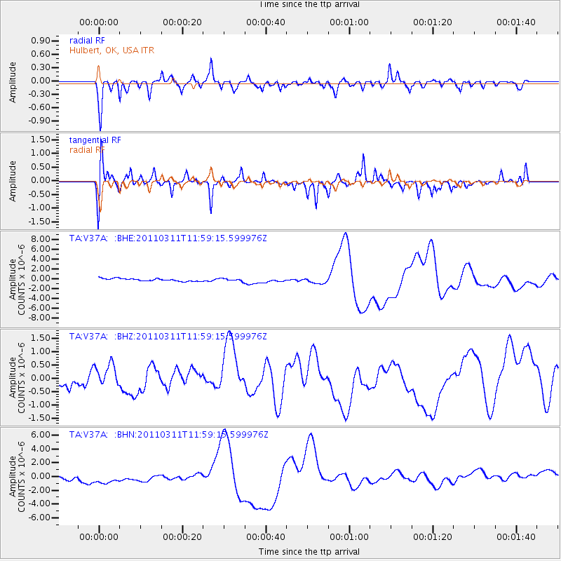
V37A Hulbert, OK, USA - Earthquake Result Viewer
*The percent match for this event was below the threshold and hence no stack was calculated.
| Earthquake location: |
Near East Coast Of Honshu, Japan |
| Earthquake latitude/longitude: |
36.0/141.2 |
| Earthquake time(UTC): |
2011/03/11 (070) 11:46:42 GMT |
| Earthquake Depth: |
18 km |
| Earthquake Magnitude: |
5.8 MB |
| Earthquake Catalog/Contributor: |
WHDF/NEIC |
|
| Network: |
TA USArray Transportable Network (new EarthScope stations) |
| Station: |
V37A Hulbert, OK, USA |
| Lat/Lon: |
35.88 N/95.14 W |
| Elevation: |
219 m |
|
| Distance: |
91.4 deg |
| Az: |
42.524 deg |
| Baz: |
317.556 deg |
| Ray Param: |
$rayparam |
*The percent match for this event was below the threshold and hence was not used in the summary stack. |
|
| Radial Match: |
52.576557 % |
| Radial Bump: |
220 |
| Transverse Match: |
32.652004 % |
| Transverse Bump: |
302 |
| SOD ConfigId: |
356183 |
| Insert Time: |
2011-08-15 18:51:51.992 +0000 |
| GWidth: |
2.5 |
| Max Bumps: |
400 |
| Tol: |
0.001 |
|
Signal To Noise
| Channel | StoN | STA | LTA |
| TA:V37A: :BHZ:20110311T11:59:15.599976Z | 0.82499814 | 4.4159992E-7 | 5.3527384E-7 |
| TA:V37A: :BHN:20110311T11:59:15.599976Z | 1.8582052 | 1.4650595E-6 | 7.884272E-7 |
| TA:V37A: :BHE:20110311T11:59:15.599976Z | 1.0006903 | 2.631621E-7 | 2.6298054E-7 |
| Arrivals |
| Ps | |
| PpPs | |
| PsPs/PpSs | |


