You are here: Home > Network List > TA - USArray Transportable Network (new EarthScope stations) Stations List
> Station M35A Neola, IA, USA > Earthquake Result Viewer
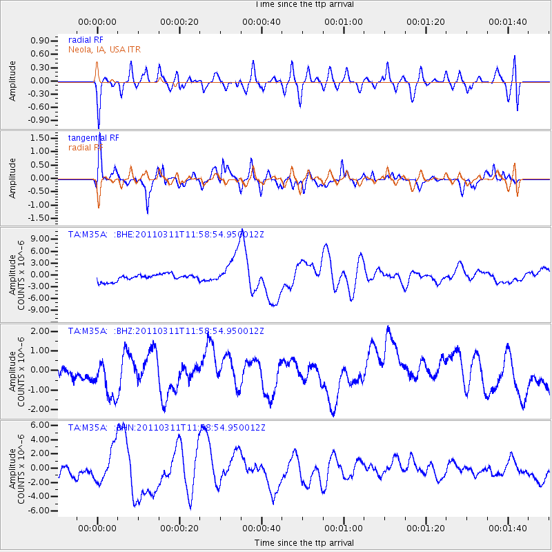
M35A Neola, IA, USA - Earthquake Result Viewer
*The percent match for this event was below the threshold and hence no stack was calculated.
| Earthquake location: |
Near East Coast Of Honshu, Japan |
| Earthquake latitude/longitude: |
36.0/141.2 |
| Earthquake time(UTC): |
2011/03/11 (070) 11:46:42 GMT |
| Earthquake Depth: |
18 km |
| Earthquake Magnitude: |
5.8 MB |
| Earthquake Catalog/Contributor: |
WHDF/NEIC |
|
| Network: |
TA USArray Transportable Network (new EarthScope stations) |
| Station: |
M35A Neola, IA, USA |
| Lat/Lon: |
41.47 N/95.69 W |
| Elevation: |
363 m |
|
| Distance: |
87.0 deg |
| Az: |
39.066 deg |
| Baz: |
317.16 deg |
| Ray Param: |
$rayparam |
*The percent match for this event was below the threshold and hence was not used in the summary stack. |
|
| Radial Match: |
48.364956 % |
| Radial Bump: |
400 |
| Transverse Match: |
37.576714 % |
| Transverse Bump: |
330 |
| SOD ConfigId: |
356183 |
| Insert Time: |
2011-08-15 18:52:42.119 +0000 |
| GWidth: |
2.5 |
| Max Bumps: |
400 |
| Tol: |
0.001 |
|
Signal To Noise
| Channel | StoN | STA | LTA |
| TA:M35A: :BHZ:20110311T11:58:54.950012Z | 3.2221029 | 1.1337086E-6 | 3.5185363E-7 |
| TA:M35A: :BHN:20110311T11:58:54.950012Z | 3.557256 | 2.5216498E-6 | 7.08875E-7 |
| TA:M35A: :BHE:20110311T11:58:54.950012Z | 5.5275393 | 4.6431405E-6 | 8.400014E-7 |
| Arrivals |
| Ps | |
| PpPs | |
| PsPs/PpSs | |


