You are here: Home > Network List > TA - USArray Transportable Network (new EarthScope stations) Stations List
> Station N33A J Bar K, Exeter, NE, USA > Earthquake Result Viewer
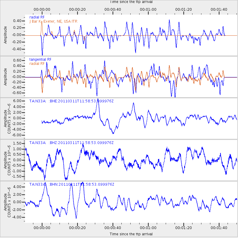
N33A J Bar K, Exeter, NE, USA - Earthquake Result Viewer
*The percent match for this event was below the threshold and hence no stack was calculated.
| Earthquake location: |
Near East Coast Of Honshu, Japan |
| Earthquake latitude/longitude: |
36.0/141.2 |
| Earthquake time(UTC): |
2011/03/11 (070) 11:46:42 GMT |
| Earthquake Depth: |
18 km |
| Earthquake Magnitude: |
5.8 MB |
| Earthquake Catalog/Contributor: |
WHDF/NEIC |
|
| Network: |
TA USArray Transportable Network (new EarthScope stations) |
| Station: |
N33A J Bar K, Exeter, NE, USA |
| Lat/Lon: |
40.74 N/97.45 W |
| Elevation: |
475 m |
|
| Distance: |
86.6 deg |
| Az: |
40.533 deg |
| Baz: |
316.093 deg |
| Ray Param: |
$rayparam |
*The percent match for this event was below the threshold and hence was not used in the summary stack. |
|
| Radial Match: |
60.70856 % |
| Radial Bump: |
400 |
| Transverse Match: |
50.424862 % |
| Transverse Bump: |
352 |
| SOD ConfigId: |
356183 |
| Insert Time: |
2011-08-15 18:53:59.885 +0000 |
| GWidth: |
2.5 |
| Max Bumps: |
400 |
| Tol: |
0.001 |
|
Signal To Noise
| Channel | StoN | STA | LTA |
| TA:N33A: :BHZ:20110311T11:58:53.099976Z | 2.0078423 | 1.2386305E-6 | 6.168963E-7 |
| TA:N33A: :BHN:20110311T11:58:53.099976Z | 5.7022552 | 2.8843633E-6 | 5.0582855E-7 |
| TA:N33A: :BHE:20110311T11:58:53.099976Z | 4.1930857 | 3.623752E-6 | 8.6422085E-7 |
| Arrivals |
| Ps | |
| PpPs | |
| PsPs/PpSs | |


