You are here: Home > Network List > TA - USArray Transportable Network (new EarthScope stations) Stations List
> Station K34A Le Mars, IA, USA > Earthquake Result Viewer
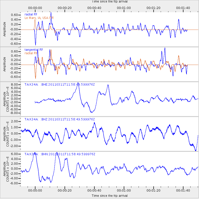
K34A Le Mars, IA, USA - Earthquake Result Viewer
*The percent match for this event was below the threshold and hence no stack was calculated.
| Earthquake location: |
Near East Coast Of Honshu, Japan |
| Earthquake latitude/longitude: |
36.0/141.2 |
| Earthquake time(UTC): |
2011/03/11 (070) 11:46:42 GMT |
| Earthquake Depth: |
18 km |
| Earthquake Magnitude: |
5.8 MB |
| Earthquake Catalog/Contributor: |
WHDF/NEIC |
|
| Network: |
TA USArray Transportable Network (new EarthScope stations) |
| Station: |
K34A Le Mars, IA, USA |
| Lat/Lon: |
42.69 N/96.10 W |
| Elevation: |
436 m |
|
| Distance: |
85.9 deg |
| Az: |
38.452 deg |
| Baz: |
316.854 deg |
| Ray Param: |
$rayparam |
*The percent match for this event was below the threshold and hence was not used in the summary stack. |
|
| Radial Match: |
44.84055 % |
| Radial Bump: |
400 |
| Transverse Match: |
20.515444 % |
| Transverse Bump: |
143 |
| SOD ConfigId: |
356183 |
| Insert Time: |
2011-08-15 18:56:56.781 +0000 |
| GWidth: |
2.5 |
| Max Bumps: |
400 |
| Tol: |
0.001 |
|
Signal To Noise
| Channel | StoN | STA | LTA |
| TA:K34A: :BHZ:20110311T11:58:49.599976Z | 2.2918155 | 9.0162763E-7 | 3.9341197E-7 |
| TA:K34A: :BHN:20110311T11:58:49.599976Z | 7.4381166 | 4.5944407E-6 | 6.176887E-7 |
| TA:K34A: :BHE:20110311T11:58:49.599976Z | 5.915407 | 4.1561234E-6 | 7.0259296E-7 |
| Arrivals |
| Ps | |
| PpPs | |
| PsPs/PpSs | |


