You are here: Home > Network List > TA - USArray Transportable Network (new EarthScope stations) Stations List
> Station K31A O'Neill, NE, USA > Earthquake Result Viewer
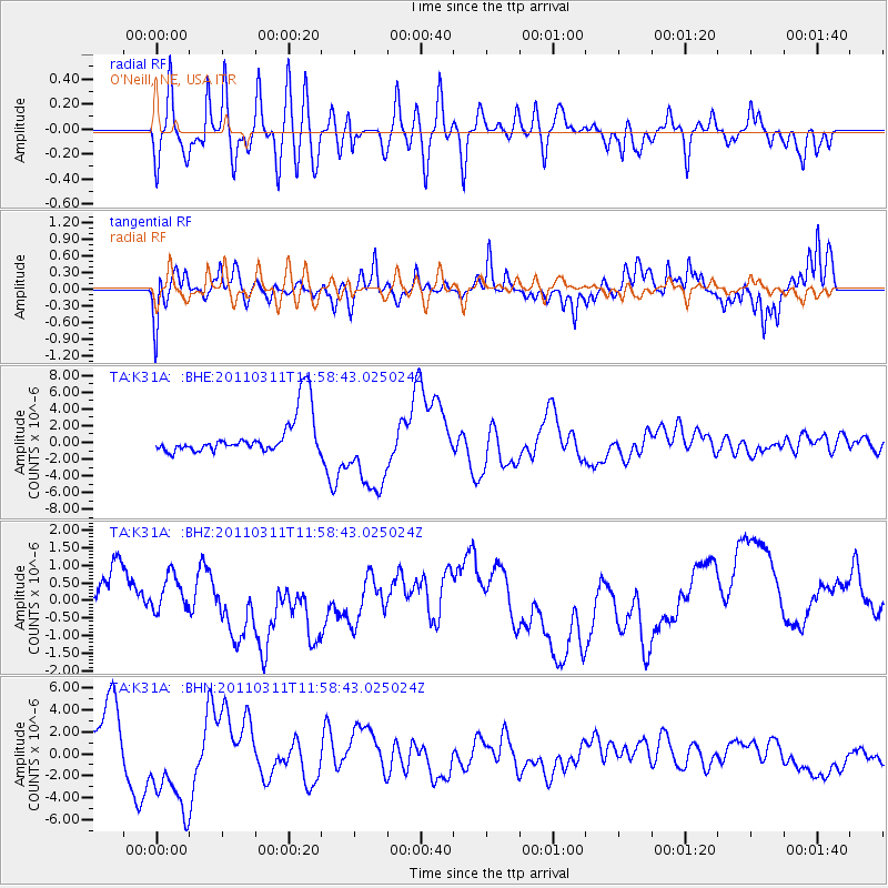
K31A O'Neill, NE, USA - Earthquake Result Viewer
*The percent match for this event was below the threshold and hence no stack was calculated.
| Earthquake location: |
Near East Coast Of Honshu, Japan |
| Earthquake latitude/longitude: |
36.0/141.2 |
| Earthquake time(UTC): |
2011/03/11 (070) 11:46:42 GMT |
| Earthquake Depth: |
18 km |
| Earthquake Magnitude: |
5.8 MB |
| Earthquake Catalog/Contributor: |
WHDF/NEIC |
|
| Network: |
TA USArray Transportable Network (new EarthScope stations) |
| Station: |
K31A O'Neill, NE, USA |
| Lat/Lon: |
42.62 N/98.75 W |
| Elevation: |
580 m |
|
| Distance: |
84.6 deg |
| Az: |
39.913 deg |
| Baz: |
315.181 deg |
| Ray Param: |
$rayparam |
*The percent match for this event was below the threshold and hence was not used in the summary stack. |
|
| Radial Match: |
46.199333 % |
| Radial Bump: |
400 |
| Transverse Match: |
54.673367 % |
| Transverse Bump: |
400 |
| SOD ConfigId: |
356183 |
| Insert Time: |
2011-08-15 19:01:38.896 +0000 |
| GWidth: |
2.5 |
| Max Bumps: |
400 |
| Tol: |
0.001 |
|
Signal To Noise
| Channel | StoN | STA | LTA |
| TA:K31A: :BHZ:20110311T11:58:43.025024Z | 1.0149771 | 4.9435334E-7 | 4.8705857E-7 |
| TA:K31A: :BHN:20110311T11:58:43.025024Z | 2.7946928 | 4.599615E-6 | 1.6458392E-6 |
| TA:K31A: :BHE:20110311T11:58:43.025024Z | 2.164236 | 4.9379178E-6 | 2.2815984E-6 |
| Arrivals |
| Ps | |
| PpPs | |
| PsPs/PpSs | |


