You are here: Home > Network List > TA - USArray Transportable Network (new EarthScope stations) Stations List
> Station F36A Milaca, MN, USA > Earthquake Result Viewer
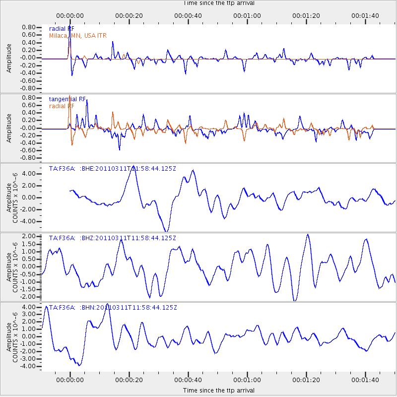
F36A Milaca, MN, USA - Earthquake Result Viewer
*The percent match for this event was below the threshold and hence no stack was calculated.
| Earthquake location: |
Near East Coast Of Honshu, Japan |
| Earthquake latitude/longitude: |
36.0/141.2 |
| Earthquake time(UTC): |
2011/03/11 (070) 11:46:42 GMT |
| Earthquake Depth: |
18 km |
| Earthquake Magnitude: |
5.8 MB |
| Earthquake Catalog/Contributor: |
WHDF/NEIC |
|
| Network: |
TA USArray Transportable Network (new EarthScope stations) |
| Station: |
F36A Milaca, MN, USA |
| Lat/Lon: |
45.86 N/93.52 W |
| Elevation: |
345 m |
|
| Distance: |
84.8 deg |
| Az: |
34.936 deg |
| Baz: |
318.357 deg |
| Ray Param: |
$rayparam |
*The percent match for this event was below the threshold and hence was not used in the summary stack. |
|
| Radial Match: |
54.308174 % |
| Radial Bump: |
400 |
| Transverse Match: |
51.97357 % |
| Transverse Bump: |
230 |
| SOD ConfigId: |
356183 |
| Insert Time: |
2011-08-15 19:05:36.774 +0000 |
| GWidth: |
2.5 |
| Max Bumps: |
400 |
| Tol: |
0.001 |
|
Signal To Noise
| Channel | StoN | STA | LTA |
| TA:F36A: :BHZ:20110311T11:58:44.125Z | 1.525814 | 1.1244657E-6 | 7.3696117E-7 |
| TA:F36A: :BHN:20110311T11:58:44.125Z | 2.7631726 | 3.2180537E-6 | 1.1646227E-6 |
| TA:F36A: :BHE:20110311T11:58:44.125Z | 2.408925 | 4.305687E-6 | 1.7873894E-6 |
| Arrivals |
| Ps | |
| PpPs | |
| PsPs/PpSs | |


