You are here: Home > Network List > TA - USArray Transportable Network (new EarthScope stations) Stations List
> Station G35A Watkins, MN, USA > Earthquake Result Viewer
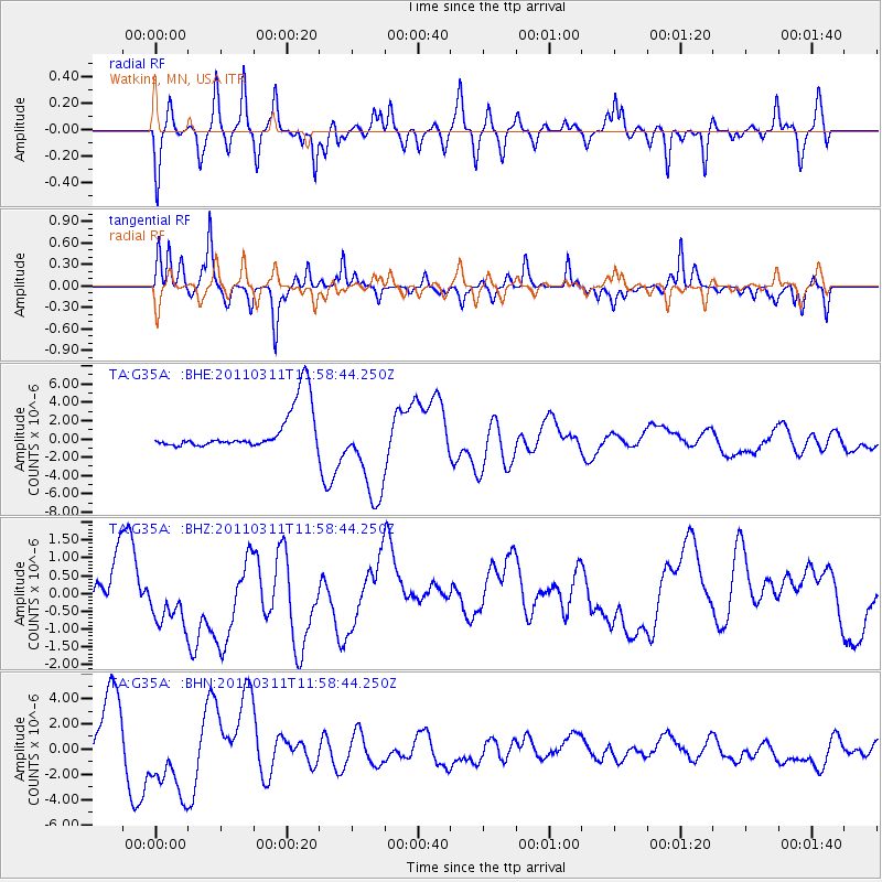
G35A Watkins, MN, USA - Earthquake Result Viewer
*The percent match for this event was below the threshold and hence no stack was calculated.
| Earthquake location: |
Near East Coast Of Honshu, Japan |
| Earthquake latitude/longitude: |
36.0/141.2 |
| Earthquake time(UTC): |
2011/03/11 (070) 11:46:42 GMT |
| Earthquake Depth: |
18 km |
| Earthquake Magnitude: |
5.8 MB |
| Earthquake Catalog/Contributor: |
WHDF/NEIC |
|
| Network: |
TA USArray Transportable Network (new EarthScope stations) |
| Station: |
G35A Watkins, MN, USA |
| Lat/Lon: |
45.22 N/94.49 W |
| Elevation: |
361 m |
|
| Distance: |
84.8 deg |
| Az: |
35.872 deg |
| Baz: |
317.758 deg |
| Ray Param: |
$rayparam |
*The percent match for this event was below the threshold and hence was not used in the summary stack. |
|
| Radial Match: |
53.976936 % |
| Radial Bump: |
313 |
| Transverse Match: |
42.72314 % |
| Transverse Bump: |
237 |
| SOD ConfigId: |
356183 |
| Insert Time: |
2011-08-15 19:06:31.030 +0000 |
| GWidth: |
2.5 |
| Max Bumps: |
400 |
| Tol: |
0.001 |
|
Signal To Noise
| Channel | StoN | STA | LTA |
| TA:G35A: :BHZ:20110311T11:58:44.250Z | 1.7100246 | 1.042628E-6 | 6.0971524E-7 |
| TA:G35A: :BHN:20110311T11:58:44.250Z | 1.8698995 | 3.201799E-6 | 1.7122841E-6 |
| TA:G35A: :BHE:20110311T11:58:44.250Z | 2.3609693 | 5.2020146E-6 | 2.2033387E-6 |
| Arrivals |
| Ps | |
| PpPs | |
| PsPs/PpSs | |


