You are here: Home > Network List > TA - USArray Transportable Network (new EarthScope stations) Stations List
> Station J36A Seneca 1, Swea City, IA, USA > Earthquake Result Viewer
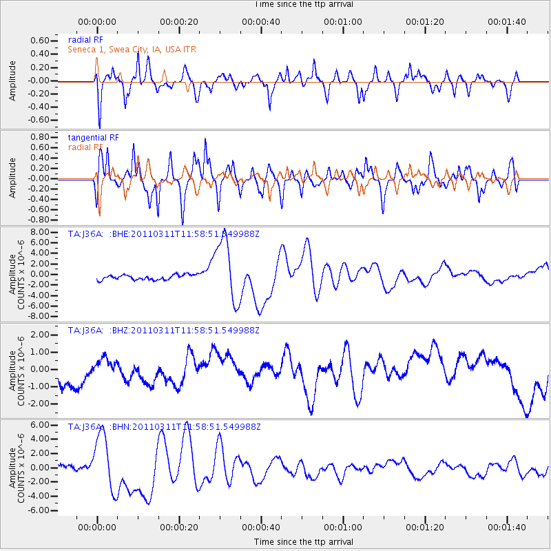
J36A Seneca 1, Swea City, IA, USA - Earthquake Result Viewer
*The percent match for this event was below the threshold and hence no stack was calculated.
| Earthquake location: |
Near East Coast Of Honshu, Japan |
| Earthquake latitude/longitude: |
36.0/141.2 |
| Earthquake time(UTC): |
2011/03/11 (070) 11:46:42 GMT |
| Earthquake Depth: |
18 km |
| Earthquake Magnitude: |
5.8 MB |
| Earthquake Catalog/Contributor: |
WHDF/NEIC |
|
| Network: |
TA USArray Transportable Network (new EarthScope stations) |
| Station: |
J36A Seneca 1, Swea City, IA, USA |
| Lat/Lon: |
43.33 N/94.34 W |
| Elevation: |
370 m |
|
| Distance: |
86.3 deg |
| Az: |
37.066 deg |
| Baz: |
317.952 deg |
| Ray Param: |
$rayparam |
*The percent match for this event was below the threshold and hence was not used in the summary stack. |
|
| Radial Match: |
46.138588 % |
| Radial Bump: |
397 |
| Transverse Match: |
36.243687 % |
| Transverse Bump: |
361 |
| SOD ConfigId: |
356183 |
| Insert Time: |
2011-08-15 19:10:55.790 +0000 |
| GWidth: |
2.5 |
| Max Bumps: |
400 |
| Tol: |
0.001 |
|
Signal To Noise
| Channel | StoN | STA | LTA |
| TA:J36A: :BHZ:20110311T11:58:51.549988Z | 0.56268543 | 4.179631E-7 | 7.428006E-7 |
| TA:J36A: :BHN:20110311T11:58:51.549988Z | 12.75287 | 4.062632E-6 | 3.185661E-7 |
| TA:J36A: :BHE:20110311T11:58:51.549988Z | 12.995743 | 6.189044E-6 | 4.7623627E-7 |
| Arrivals |
| Ps | |
| PpPs | |
| PsPs/PpSs | |


