You are here: Home > Network List > TA - USArray Transportable Network (new EarthScope stations) Stations List
> Station I37A Lemond, Waseca, MN, USA > Earthquake Result Viewer
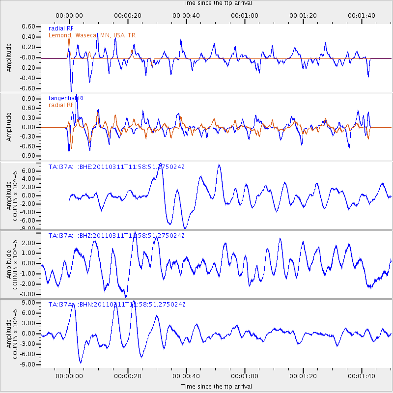
I37A Lemond, Waseca, MN, USA - Earthquake Result Viewer
*The percent match for this event was below the threshold and hence no stack was calculated.
| Earthquake location: |
Near East Coast Of Honshu, Japan |
| Earthquake latitude/longitude: |
36.0/141.2 |
| Earthquake time(UTC): |
2011/03/11 (070) 11:46:42 GMT |
| Earthquake Depth: |
18 km |
| Earthquake Magnitude: |
5.8 MB |
| Earthquake Catalog/Contributor: |
WHDF/NEIC |
|
| Network: |
TA USArray Transportable Network (new EarthScope stations) |
| Station: |
I37A Lemond, Waseca, MN, USA |
| Lat/Lon: |
44.01 N/93.40 W |
| Elevation: |
371 m |
|
| Distance: |
86.2 deg |
| Az: |
36.099 deg |
| Baz: |
318.535 deg |
| Ray Param: |
$rayparam |
*The percent match for this event was below the threshold and hence was not used in the summary stack. |
|
| Radial Match: |
59.948944 % |
| Radial Bump: |
400 |
| Transverse Match: |
50.614933 % |
| Transverse Bump: |
342 |
| SOD ConfigId: |
356183 |
| Insert Time: |
2011-08-15 19:11:43.543 +0000 |
| GWidth: |
2.5 |
| Max Bumps: |
400 |
| Tol: |
0.001 |
|
Signal To Noise
| Channel | StoN | STA | LTA |
| TA:I37A: :BHZ:20110311T11:58:51.275024Z | 1.3426617 | 9.876331E-7 | 7.3557857E-7 |
| TA:I37A: :BHN:20110311T11:58:51.275024Z | 6.298667 | 5.995293E-6 | 9.5183526E-7 |
| TA:I37A: :BHE:20110311T11:58:51.275024Z | 6.5515394 | 5.7522825E-6 | 8.7800476E-7 |
| Arrivals |
| Ps | |
| PpPs | |
| PsPs/PpSs | |


