You are here: Home > Network List > TA - USArray Transportable Network (new EarthScope stations) Stations List
> Station S39A Bolivar, MO, USA > Earthquake Result Viewer
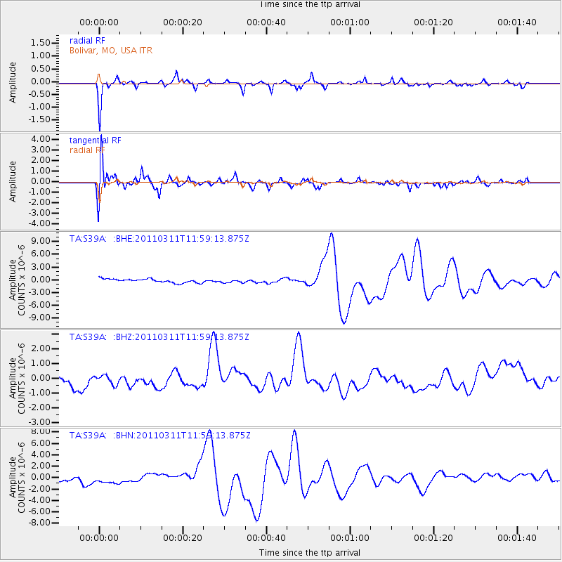
S39A Bolivar, MO, USA - Earthquake Result Viewer
*The percent match for this event was below the threshold and hence no stack was calculated.
| Earthquake location: |
Near East Coast Of Honshu, Japan |
| Earthquake latitude/longitude: |
36.0/141.2 |
| Earthquake time(UTC): |
2011/03/11 (070) 11:46:42 GMT |
| Earthquake Depth: |
18 km |
| Earthquake Magnitude: |
5.8 MB |
| Earthquake Catalog/Contributor: |
WHDF/NEIC |
|
| Network: |
TA USArray Transportable Network (new EarthScope stations) |
| Station: |
S39A Bolivar, MO, USA |
| Lat/Lon: |
37.69 N/93.32 W |
| Elevation: |
331 m |
|
| Distance: |
91.0 deg |
| Az: |
40.232 deg |
| Baz: |
318.687 deg |
| Ray Param: |
$rayparam |
*The percent match for this event was below the threshold and hence was not used in the summary stack. |
|
| Radial Match: |
69.25273 % |
| Radial Bump: |
237 |
| Transverse Match: |
61.553013 % |
| Transverse Bump: |
400 |
| SOD ConfigId: |
356183 |
| Insert Time: |
2011-08-15 19:17:19.356 +0000 |
| GWidth: |
2.5 |
| Max Bumps: |
400 |
| Tol: |
0.001 |
|
Signal To Noise
| Channel | StoN | STA | LTA |
| TA:S39A: :BHZ:20110311T11:59:13.875Z | 0.82418114 | 3.722386E-7 | 4.516466E-7 |
| TA:S39A: :BHN:20110311T11:59:13.875Z | 1.4924891 | 1.1820085E-6 | 7.919712E-7 |
| TA:S39A: :BHE:20110311T11:59:13.875Z | 0.8989776 | 3.920315E-7 | 4.3608594E-7 |
| Arrivals |
| Ps | |
| PpPs | |
| PsPs/PpSs | |


