You are here: Home > Network List > US - United States National Seismic Network Stations List
> Station WMOK Wichita Mountains, Oklahoma, USA > Earthquake Result Viewer
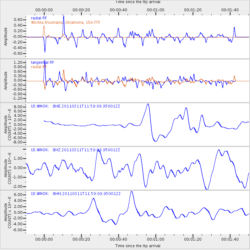
WMOK Wichita Mountains, Oklahoma, USA - Earthquake Result Viewer
*The percent match for this event was below the threshold and hence no stack was calculated.
| Earthquake location: |
Near East Coast Of Honshu, Japan |
| Earthquake latitude/longitude: |
36.0/141.2 |
| Earthquake time(UTC): |
2011/03/11 (070) 11:46:42 GMT |
| Earthquake Depth: |
18 km |
| Earthquake Magnitude: |
5.8 MB |
| Earthquake Catalog/Contributor: |
WHDF/NEIC |
|
| Network: |
US United States National Seismic Network |
| Station: |
WMOK Wichita Mountains, Oklahoma, USA |
| Lat/Lon: |
34.74 N/98.78 W |
| Elevation: |
486 m |
|
| Distance: |
90.1 deg |
| Az: |
45.469 deg |
| Baz: |
315.422 deg |
| Ray Param: |
$rayparam |
*The percent match for this event was below the threshold and hence was not used in the summary stack. |
|
| Radial Match: |
32.611393 % |
| Radial Bump: |
319 |
| Transverse Match: |
37.926064 % |
| Transverse Bump: |
254 |
| SOD ConfigId: |
356183 |
| Insert Time: |
2011-08-15 19:25:06.660 +0000 |
| GWidth: |
2.5 |
| Max Bumps: |
400 |
| Tol: |
0.001 |
|
Signal To Noise
| Channel | StoN | STA | LTA |
| US:WMOK: :BHZ:20110311T11:59:09.950012Z | 0.8879223 | 5.870968E-7 | 6.6120293E-7 |
| US:WMOK: :BHN:20110311T11:59:09.950012Z | 2.3860345 | 8.47193E-7 | 3.5506318E-7 |
| US:WMOK: :BHE:20110311T11:59:09.950012Z | 0.7915674 | 5.150845E-7 | 6.5071464E-7 |
| Arrivals |
| Ps | |
| PpPs | |
| PsPs/PpSs | |


