You are here: Home > Network List > UW - Pacific Northwest Regional Seismic Network Stations List
> Station PASS Maple Falls, WA, USA > Earthquake Result Viewer
PASS Maple Falls, WA, USA - Earthquake Result Viewer
| Earthquake location: |
Eastern Caucasus |
| Earthquake latitude/longitude: |
40.3/48.8 |
| Earthquake time(UTC): |
2014/02/10 (041) 12:06:46 GMT |
| Earthquake Depth: |
63 km |
| Earthquake Magnitude: |
5.5 MW |
| Earthquake Catalog/Contributor: |
ISC/ISC |
|
| Network: |
UW Pacific Northwest Regional Seismic Network |
| Station: |
PASS Maple Falls, WA, USA |
| Lat/Lon: |
49.00 N/122.09 W |
| Elevation: |
174 m |
|
| Distance: |
90.7 deg |
| Az: |
353.986 deg |
| Baz: |
6.992 deg |
| Ray Param: |
0.04164062 |
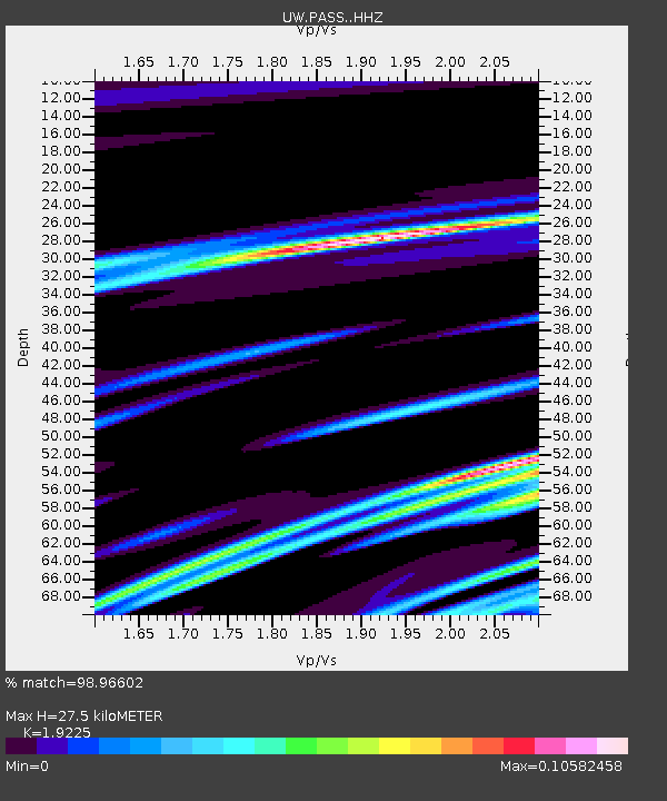
| Estimated Moho Depth: |
27.5 km |
| Estimated Crust Vp/Vs: |
1.92 |
| Assumed Crust Vp: |
6.566 km/s |
| Estimated Crust Vs: |
3.415 km/s |
| Estimated Crust Poisson's Ratio: |
0.31 |
|
| Radial Match: |
98.96602 % |
| Radial Bump: |
124 |
| Transverse Match: |
71.44879 % |
| Transverse Bump: |
400 |
| SOD ConfigId: |
3390531 |
| Insert Time: |
2019-04-10 07:18:39.094 +0000 |
| GWidth: |
2.5 |
| Max Bumps: |
400 |
| Tol: |
0.001 |
|
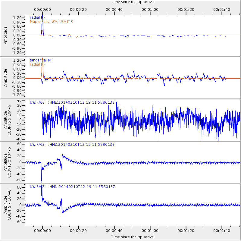
Signal To Noise
| Channel | StoN | STA | LTA |
| UW:PASS: :HHZ:20140210T12:19:11.558013Z | 10.978172 | 1.9502735E-5 | 1.776501E-6 |
| UW:PASS: :HHN:20140210T12:19:11.558013Z | 10.543833 | 2.0437757E-5 | 1.9383613E-6 |
| UW:PASS: :HHE:20140210T12:19:11.558013Z | 1.06713 | 1.3499767E-5 | 1.26505365E-5 |
| Arrivals |
| Ps | 3.9 SECOND |
| PpPs | 12 SECOND |
| PsPs/PpSs | 16 SECOND |


