You are here: Home > Network List > XG92 - Rocky Mountain Front Stations List
> Station WIG Orchard, CO > Earthquake Result Viewer
WIG Orchard, CO - Earthquake Result Viewer
| Earthquake location: |
Kuril Islands |
| Earthquake latitude/longitude: |
44.7/149.5 |
| Earthquake time(UTC): |
1992/07/10 (192) 09:31:26 GMT |
| Earthquake Depth: |
11 km |
| Earthquake Magnitude: |
6.1 MB, 6.5 MS |
| Earthquake Catalog/Contributor: |
WHDF/NEIC |
|
| Network: |
XG Rocky Mountain Front |
| Station: |
WIG Orchard, CO |
| Lat/Lon: |
40.33 N/104.07 W |
| Elevation: |
1368 m |
|
| Distance: |
72.7 deg |
| Az: |
50.178 deg |
| Baz: |
314.203 deg |
| Ray Param: |
0.05348541 |
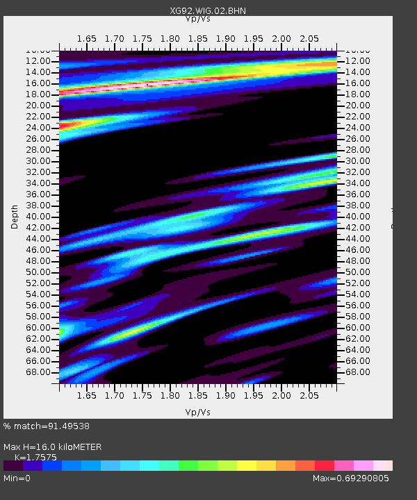
| Estimated Moho Depth: |
16.0 km |
| Estimated Crust Vp/Vs: |
1.76 |
| Assumed Crust Vp: |
6.306 km/s |
| Estimated Crust Vs: |
3.588 km/s |
| Estimated Crust Poisson's Ratio: |
0.26 |
|
| Radial Match: |
91.49538 % |
| Radial Bump: |
400 |
| Transverse Match: |
74.407555 % |
| Transverse Bump: |
400 |
| SOD ConfigId: |
3286 |
| Insert Time: |
2010-02-25 20:12:09.938 +0000 |
| GWidth: |
2.5 |
| Max Bumps: |
400 |
| Tol: |
0.001 |
|
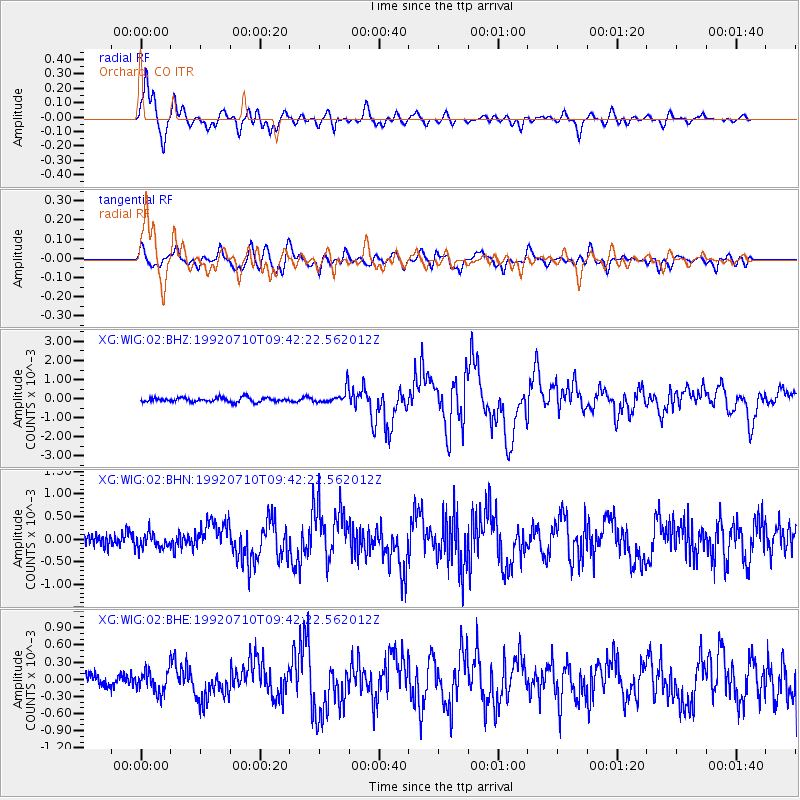
Signal To Noise
| Channel | StoN | STA | LTA |
| XG:WIG:02:BHN:19920710T09:42:22.562012Z | 1.0254096 | 1.6672262E-4 | 1.6259123E-4 |
| XG:WIG:02:BHE:19920710T09:42:22.562012Z | 1.6497416 | 1.8886209E-4 | 1.1447979E-4 |
| XG:WIG:02:BHZ:19920710T09:42:22.562012Z | 3.3461552 | 3.8544045E-4 | 1.1518905E-4 |
| Arrivals |
| Ps | 2.0 SECOND |
| PpPs | 6.8 SECOND |
| PsPs/PpSs | 8.8 SECOND |


