You are here: Home > Network List > TA - USArray Transportable Network (new EarthScope stations) Stations List
> Station N28A Pribbeno Ranch, Imperial, NE, USA > Earthquake Result Viewer
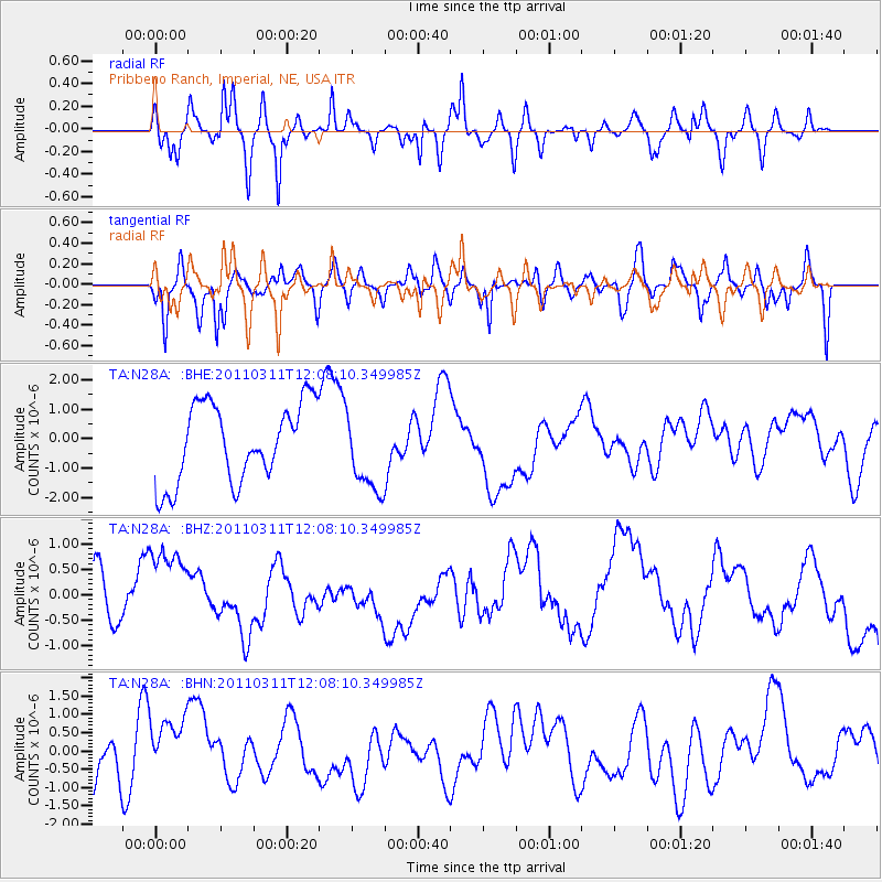
N28A Pribbeno Ranch, Imperial, NE, USA - Earthquake Result Viewer
*The percent match for this event was below the threshold and hence no stack was calculated.
| Earthquake location: |
Near East Coast Of Honshu, Japan |
| Earthquake latitude/longitude: |
36.3/141.5 |
| Earthquake time(UTC): |
2011/03/11 (070) 11:56:13 GMT |
| Earthquake Depth: |
23 km |
| Earthquake Magnitude: |
5.5 MB |
| Earthquake Catalog/Contributor: |
WHDF/NEIC |
|
| Network: |
TA USArray Transportable Network (new EarthScope stations) |
| Station: |
N28A Pribbeno Ranch, Imperial, NE, USA |
| Lat/Lon: |
40.69 N/101.54 W |
| Elevation: |
1009 m |
|
| Distance: |
84.0 deg |
| Az: |
42.974 deg |
| Baz: |
313.577 deg |
| Ray Param: |
$rayparam |
*The percent match for this event was below the threshold and hence was not used in the summary stack. |
|
| Radial Match: |
66.59128 % |
| Radial Bump: |
400 |
| Transverse Match: |
52.413174 % |
| Transverse Bump: |
400 |
| SOD ConfigId: |
356183 |
| Insert Time: |
2011-08-15 20:54:10.213 +0000 |
| GWidth: |
2.5 |
| Max Bumps: |
400 |
| Tol: |
0.001 |
|
Signal To Noise
| Channel | StoN | STA | LTA |
| TA:N28A: :BHZ:20110311T12:08:10.349985Z | 1.4479603 | 1.1077992E-6 | 7.6507575E-7 |
| TA:N28A: :BHN:20110311T12:08:10.349985Z | 1.554935 | 1.2520155E-6 | 8.051884E-7 |
| TA:N28A: :BHE:20110311T12:08:10.349985Z | 1.0299964 | 1.3523692E-6 | 1.3129844E-6 |
| Arrivals |
| Ps | |
| PpPs | |
| PsPs/PpSs | |


