You are here: Home > Network List > XG92 - Rocky Mountain Front Stations List
> Station WIG Orchard, CO > Earthquake Result Viewer
WIG Orchard, CO - Earthquake Result Viewer
| Earthquake location: |
South Of Panama |
| Earthquake latitude/longitude: |
6.1/-82.4 |
| Earthquake time(UTC): |
1992/06/26 (178) 11:32:30 GMT |
| Earthquake Depth: |
33 km |
| Earthquake Magnitude: |
5.8 MB, 5.4 MS |
| Earthquake Catalog/Contributor: |
WHDF/NEIC |
|
| Network: |
XG Rocky Mountain Front |
| Station: |
WIG Orchard, CO |
| Lat/Lon: |
40.33 N/104.07 W |
| Elevation: |
1368 m |
|
| Distance: |
39.2 deg |
| Az: |
333.442 deg |
| Baz: |
144.442 deg |
| Ray Param: |
0.07504296 |
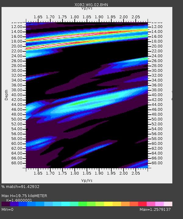
| Estimated Moho Depth: |
19.75 km |
| Estimated Crust Vp/Vs: |
1.68 |
| Assumed Crust Vp: |
6.306 km/s |
| Estimated Crust Vs: |
3.754 km/s |
| Estimated Crust Poisson's Ratio: |
0.23 |
|
| Radial Match: |
91.42932 % |
| Radial Bump: |
240 |
| Transverse Match: |
59.272976 % |
| Transverse Bump: |
400 |
| SOD ConfigId: |
3286 |
| Insert Time: |
2010-02-25 20:12:11.615 +0000 |
| GWidth: |
2.5 |
| Max Bumps: |
400 |
| Tol: |
0.001 |
|
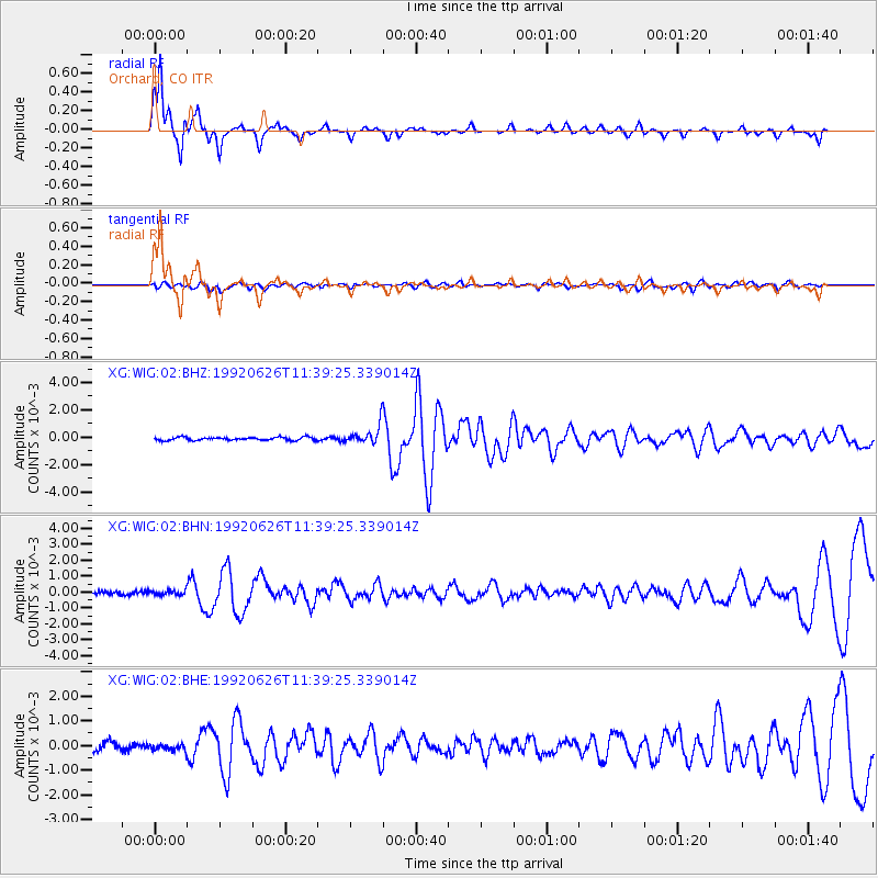
Signal To Noise
| Channel | StoN | STA | LTA |
| XG:WIG:02:BHN:19920626T11:39:25.339014Z | 0.94665784 | 1.4026673E-4 | 1.4817045E-4 |
| XG:WIG:02:BHE:19920626T11:39:25.339014Z | 0.67999303 | 1.3569763E-4 | 1.9955738E-4 |
| XG:WIG:02:BHZ:19920626T11:39:25.339014Z | 5.9505777 | 6.776143E-4 | 1.138737E-4 |
| Arrivals |
| Ps | 2.3 SECOND |
| PpPs | 7.8 SECOND |
| PsPs/PpSs | 10 SECOND |


