You are here: Home > Network List > CI - Caltech Regional Seismic Network Stations List
> Station TIN Tinemaha, Big Pine, CA, USA > Earthquake Result Viewer
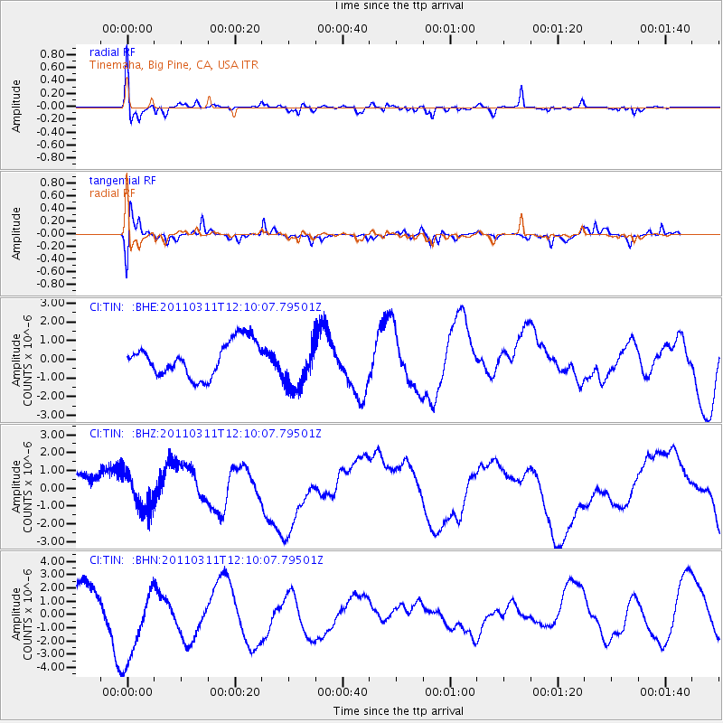
TIN Tinemaha, Big Pine, CA, USA - Earthquake Result Viewer
*The percent match for this event was below the threshold and hence no stack was calculated.
| Earthquake location: |
Off East Coast Of Honshu, Japan |
| Earthquake latitude/longitude: |
35.8/142.1 |
| Earthquake time(UTC): |
2011/03/11 (070) 11:58:54 GMT |
| Earthquake Depth: |
35 km |
| Earthquake Magnitude: |
5.6 MB |
| Earthquake Catalog/Contributor: |
WHDF/NEIC |
|
| Network: |
CI Caltech Regional Seismic Network |
| Station: |
TIN Tinemaha, Big Pine, CA, USA |
| Lat/Lon: |
37.05 N/118.23 W |
| Elevation: |
1197 m |
|
| Distance: |
76.1 deg |
| Az: |
54.314 deg |
| Baz: |
304.327 deg |
| Ray Param: |
$rayparam |
*The percent match for this event was below the threshold and hence was not used in the summary stack. |
|
| Radial Match: |
72.28445 % |
| Radial Bump: |
400 |
| Transverse Match: |
48.820946 % |
| Transverse Bump: |
400 |
| SOD ConfigId: |
356183 |
| Insert Time: |
2011-08-15 22:21:33.469 +0000 |
| GWidth: |
2.5 |
| Max Bumps: |
400 |
| Tol: |
0.001 |
|
Signal To Noise
| Channel | StoN | STA | LTA |
| CI:TIN: :BHZ:20110311T12:10:07.79501Z | 1.1847644 | 9.8802E-7 | 8.3393803E-7 |
| CI:TIN: :BHN:20110311T12:10:07.79501Z | 2.1594987 | 3.149878E-6 | 1.4586153E-6 |
| CI:TIN: :BHE:20110311T12:10:07.79501Z | 1.4653329 | 1.3308302E-6 | 9.082101E-7 |
| Arrivals |
| Ps | |
| PpPs | |
| PsPs/PpSs | |


