You are here: Home > Network List > AZ - ANZA Regional Network Stations List
> Station MONP2 Monument Peak TA Vault, Anza, CA, USA > Earthquake Result Viewer
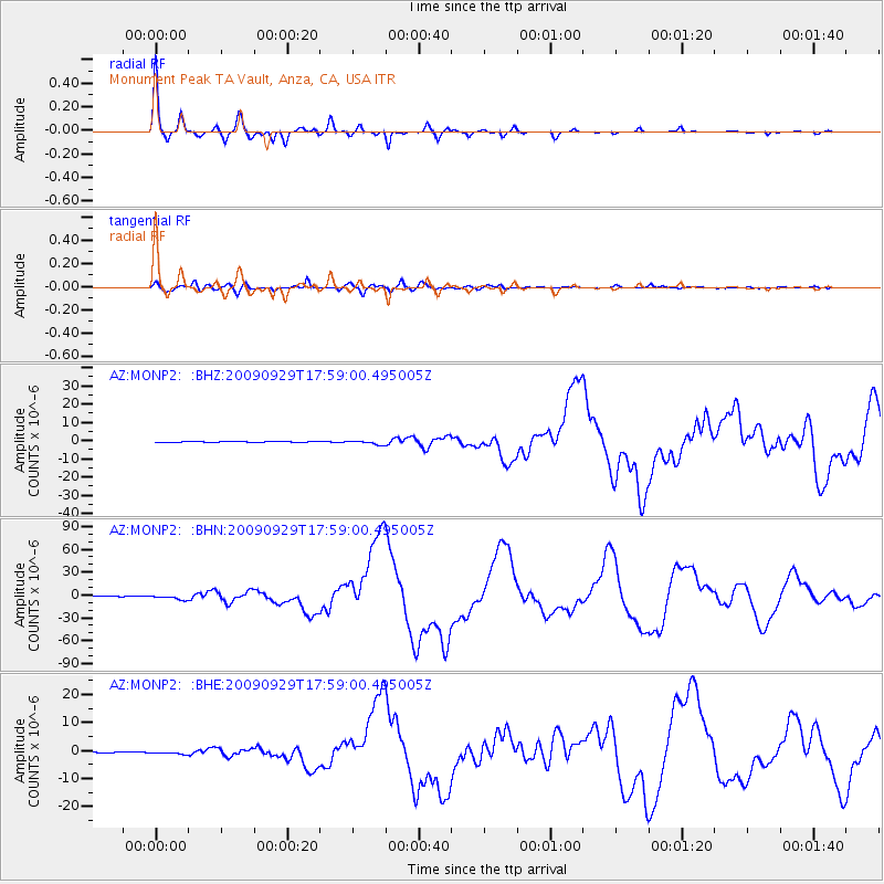
MONP2 Monument Peak TA Vault, Anza, CA, USA - Earthquake Result Viewer
| Earthquake location: |
Samoa Islands Region |
| Earthquake latitude/longitude: |
-15.5/-172.1 |
| Earthquake time(UTC): |
2009/09/29 (272) 17:48:10 GMT |
| Earthquake Depth: |
18 km |
| Earthquake Magnitude: |
7.1 MB, 8.1 MS, 8.1 MW, 8.0 MW |
| Earthquake Catalog/Contributor: |
WHDF/NEIC |
|
| Network: |
AZ ANZA Regional Network |
| Station: |
MONP2 Monument Peak TA Vault, Anza, CA, USA |
| Lat/Lon: |
32.89 N/116.42 W |
| Elevation: |
1000 m |
|
| Distance: |
71.7 deg |
| Az: |
47.04 deg |
| Baz: |
236.996 deg |
| Ray Param: |
0.05413754 |
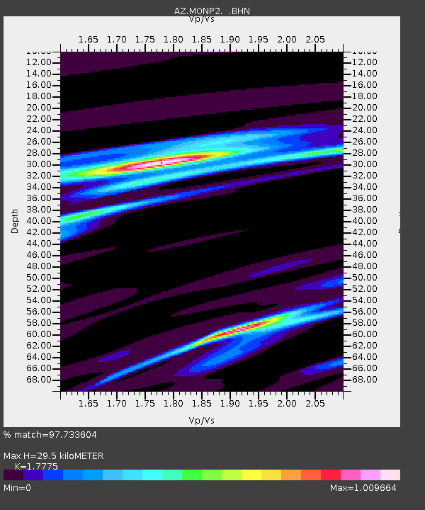
| Estimated Moho Depth: |
29.5 km |
| Estimated Crust Vp/Vs: |
1.78 |
| Assumed Crust Vp: |
6.264 km/s |
| Estimated Crust Vs: |
3.524 km/s |
| Estimated Crust Poisson's Ratio: |
0.27 |
|
| Radial Match: |
97.733604 % |
| Radial Bump: |
312 |
| Transverse Match: |
94.6308 % |
| Transverse Bump: |
400 |
| SOD ConfigId: |
2622 |
| Insert Time: |
2010-02-26 20:03:33.259 +0000 |
| GWidth: |
2.5 |
| Max Bumps: |
400 |
| Tol: |
0.001 |
|
Signal To Noise
| Channel | StoN | STA | LTA |
| AZ:MONP2: :BHN:20090929T17:59:00.495005Z | 13.596674 | 2.7608369E-6 | 2.0305238E-7 |
| AZ:MONP2: :BHE:20090929T17:59:00.495005Z | 2.8402224 | 4.867322E-7 | 1.7137116E-7 |
| AZ:MONP2: :BHZ:20090929T17:59:00.495005Z | 5.012006 | 1.0705317E-6 | 2.1359345E-7 |
| Arrivals |
| Ps | 3.8 SECOND |
| PpPs | 13 SECOND |
| PsPs/PpSs | 16 SECOND |


