You are here: Home > Network List > TA - USArray Transportable Network (new EarthScope stations) Stations List
> Station MSTX Muleshoe, TX, USA > Earthquake Result Viewer
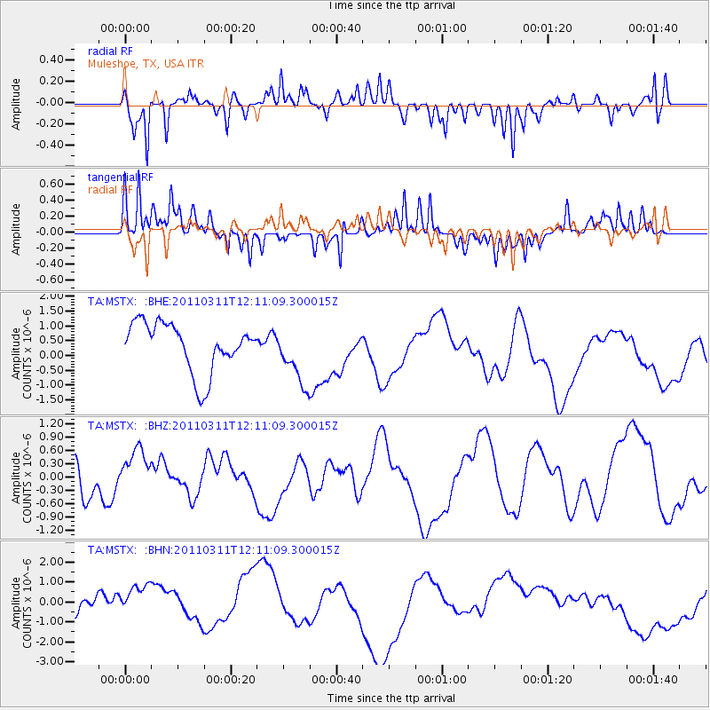
MSTX Muleshoe, TX, USA - Earthquake Result Viewer
*The percent match for this event was below the threshold and hence no stack was calculated.
| Earthquake location: |
Off East Coast Of Honshu, Japan |
| Earthquake latitude/longitude: |
35.8/142.1 |
| Earthquake time(UTC): |
2011/03/11 (070) 11:58:54 GMT |
| Earthquake Depth: |
35 km |
| Earthquake Magnitude: |
5.6 MB |
| Earthquake Catalog/Contributor: |
WHDF/NEIC |
|
| Network: |
TA USArray Transportable Network (new EarthScope stations) |
| Station: |
MSTX Muleshoe, TX, USA |
| Lat/Lon: |
33.97 N/102.77 W |
| Elevation: |
1167 m |
|
| Distance: |
87.9 deg |
| Az: |
48.833 deg |
| Baz: |
312.541 deg |
| Ray Param: |
$rayparam |
*The percent match for this event was below the threshold and hence was not used in the summary stack. |
|
| Radial Match: |
59.597336 % |
| Radial Bump: |
274 |
| Transverse Match: |
67.14231 % |
| Transverse Bump: |
256 |
| SOD ConfigId: |
356183 |
| Insert Time: |
2011-08-15 23:06:39.640 +0000 |
| GWidth: |
2.5 |
| Max Bumps: |
400 |
| Tol: |
0.001 |
|
Signal To Noise
| Channel | StoN | STA | LTA |
| TA:MSTX: :BHZ:20110311T12:11:09.300015Z | 1.1472579 | 6.274559E-7 | 5.4691793E-7 |
| TA:MSTX: :BHN:20110311T12:11:09.300015Z | 1.4837826 | 1.0321415E-6 | 6.9561503E-7 |
| TA:MSTX: :BHE:20110311T12:11:09.300015Z | 1.2065032 | 9.918718E-7 | 8.221047E-7 |
| Arrivals |
| Ps | |
| PpPs | |
| PsPs/PpSs | |


