You are here: Home > Network List > TA - USArray Transportable Network (new EarthScope stations) Stations List
> Station I28A Midland, SD, USA > Earthquake Result Viewer
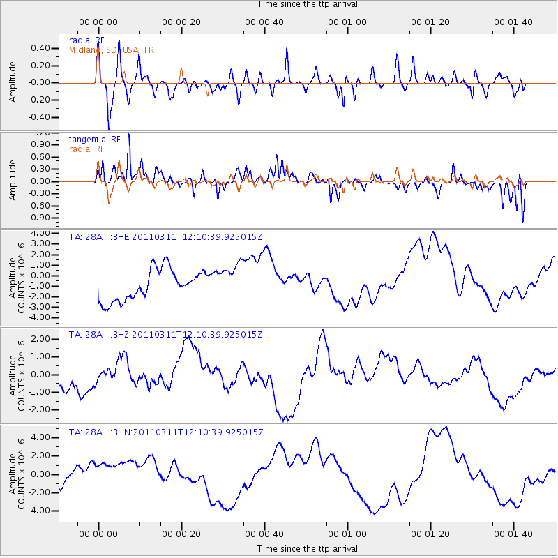
I28A Midland, SD, USA - Earthquake Result Viewer
*The percent match for this event was below the threshold and hence no stack was calculated.
| Earthquake location: |
Off East Coast Of Honshu, Japan |
| Earthquake latitude/longitude: |
35.8/142.1 |
| Earthquake time(UTC): |
2011/03/11 (070) 11:58:54 GMT |
| Earthquake Depth: |
35 km |
| Earthquake Magnitude: |
5.6 MB |
| Earthquake Catalog/Contributor: |
WHDF/NEIC |
|
| Network: |
TA USArray Transportable Network (new EarthScope stations) |
| Station: |
I28A Midland, SD, USA |
| Lat/Lon: |
44.00 N/101.17 W |
| Elevation: |
655 m |
|
| Distance: |
82.0 deg |
| Az: |
40.594 deg |
| Baz: |
312.827 deg |
| Ray Param: |
$rayparam |
*The percent match for this event was below the threshold and hence was not used in the summary stack. |
|
| Radial Match: |
56.88918 % |
| Radial Bump: |
400 |
| Transverse Match: |
61.76611 % |
| Transverse Bump: |
364 |
| SOD ConfigId: |
356183 |
| Insert Time: |
2011-08-15 23:15:17.098 +0000 |
| GWidth: |
2.5 |
| Max Bumps: |
400 |
| Tol: |
0.001 |
|
Signal To Noise
| Channel | StoN | STA | LTA |
| TA:I28A: :BHZ:20110311T12:10:39.925015Z | 0.7346741 | 3.814103E-7 | 5.191558E-7 |
| TA:I28A: :BHN:20110311T12:10:39.925015Z | 3.2610571 | 2.3165906E-6 | 7.103802E-7 |
| TA:I28A: :BHE:20110311T12:10:39.925015Z | 1.2028471 | 1.7425834E-6 | 1.4487156E-6 |
| Arrivals |
| Ps | |
| PpPs | |
| PsPs/PpSs | |


