You are here: Home > Network List > TA - USArray Transportable Network (new EarthScope stations) Stations List
> Station H26A Fairpoint, SD, USA > Earthquake Result Viewer
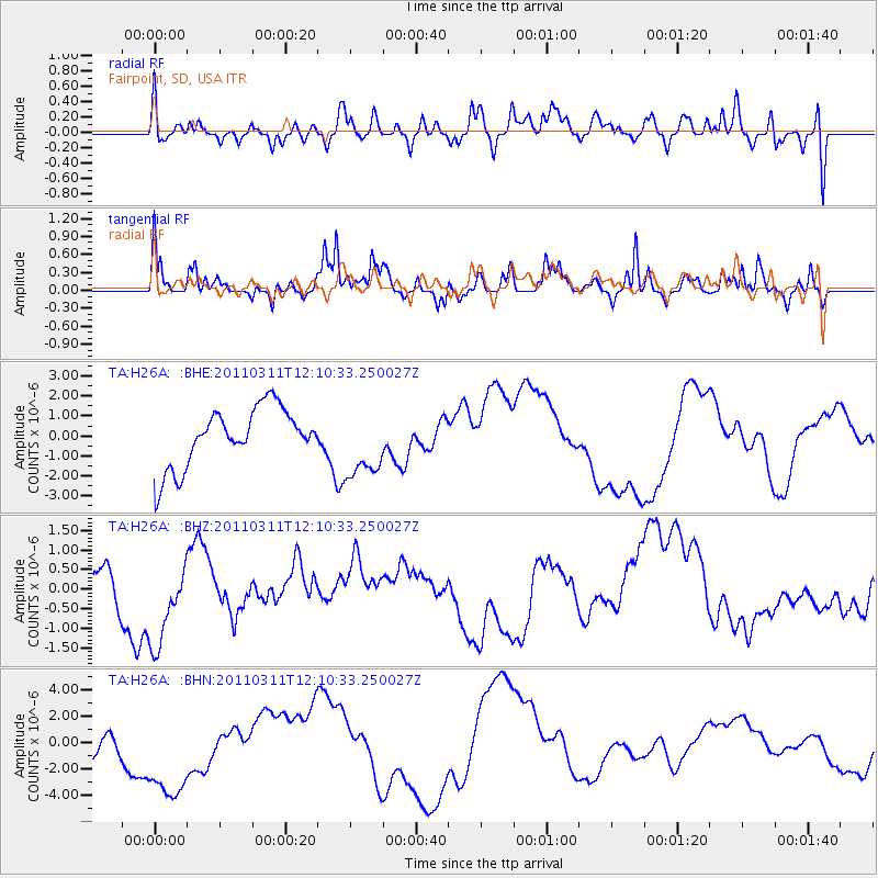
H26A Fairpoint, SD, USA - Earthquake Result Viewer
*The percent match for this event was below the threshold and hence no stack was calculated.
| Earthquake location: |
Off East Coast Of Honshu, Japan |
| Earthquake latitude/longitude: |
35.8/142.1 |
| Earthquake time(UTC): |
2011/03/11 (070) 11:58:54 GMT |
| Earthquake Depth: |
35 km |
| Earthquake Magnitude: |
5.6 MB |
| Earthquake Catalog/Contributor: |
WHDF/NEIC |
|
| Network: |
TA USArray Transportable Network (new EarthScope stations) |
| Station: |
H26A Fairpoint, SD, USA |
| Lat/Lon: |
44.62 N/102.77 W |
| Elevation: |
879 m |
|
| Distance: |
80.8 deg |
| Az: |
40.917 deg |
| Baz: |
311.758 deg |
| Ray Param: |
$rayparam |
*The percent match for this event was below the threshold and hence was not used in the summary stack. |
|
| Radial Match: |
53.53602 % |
| Radial Bump: |
400 |
| Transverse Match: |
38.587605 % |
| Transverse Bump: |
359 |
| SOD ConfigId: |
356183 |
| Insert Time: |
2011-08-15 23:16:17.772 +0000 |
| GWidth: |
2.5 |
| Max Bumps: |
400 |
| Tol: |
0.001 |
|
Signal To Noise
| Channel | StoN | STA | LTA |
| TA:H26A: :BHZ:20110311T12:10:33.250027Z | 1.2764128 | 1.2198554E-6 | 9.556903E-7 |
| TA:H26A: :BHN:20110311T12:10:33.250027Z | 3.3872023 | 4.6155797E-6 | 1.3626526E-6 |
| TA:H26A: :BHE:20110311T12:10:33.250027Z | 1.1938481 | 1.7346999E-6 | 1.4530323E-6 |
| Arrivals |
| Ps | |
| PpPs | |
| PsPs/PpSs | |


