You are here: Home > Network List > TA - USArray Transportable Network (new EarthScope stations) Stations List
> Station W33A Caddo, Fort Cobb, OK, USA > Earthquake Result Viewer
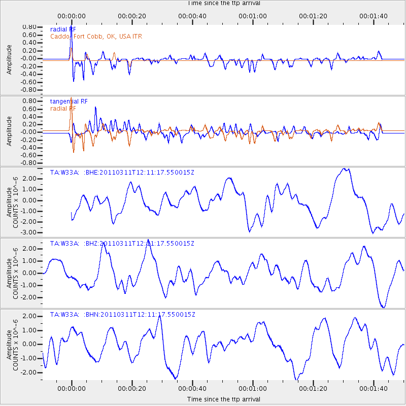
W33A Caddo, Fort Cobb, OK, USA - Earthquake Result Viewer
*The percent match for this event was below the threshold and hence no stack was calculated.
| Earthquake location: |
Off East Coast Of Honshu, Japan |
| Earthquake latitude/longitude: |
35.8/142.1 |
| Earthquake time(UTC): |
2011/03/11 (070) 11:58:54 GMT |
| Earthquake Depth: |
35 km |
| Earthquake Magnitude: |
5.6 MB |
| Earthquake Catalog/Contributor: |
WHDF/NEIC |
|
| Network: |
TA USArray Transportable Network (new EarthScope stations) |
| Station: |
W33A Caddo, Fort Cobb, OK, USA |
| Lat/Lon: |
35.15 N/98.47 W |
| Elevation: |
414 m |
|
| Distance: |
89.7 deg |
| Az: |
45.525 deg |
| Baz: |
314.903 deg |
| Ray Param: |
$rayparam |
*The percent match for this event was below the threshold and hence was not used in the summary stack. |
|
| Radial Match: |
67.160385 % |
| Radial Bump: |
400 |
| Transverse Match: |
60.17113 % |
| Transverse Bump: |
400 |
| SOD ConfigId: |
356183 |
| Insert Time: |
2011-08-15 23:27:58.331 +0000 |
| GWidth: |
2.5 |
| Max Bumps: |
400 |
| Tol: |
0.001 |
|
Signal To Noise
| Channel | StoN | STA | LTA |
| TA:W33A: :BHZ:20110311T12:11:17.550015Z | 0.5603037 | 6.667629E-7 | 1.1900028E-6 |
| TA:W33A: :BHN:20110311T12:11:17.550015Z | 0.7484329 | 7.901015E-7 | 1.0556745E-6 |
| TA:W33A: :BHE:20110311T12:11:17.550015Z | 0.5465012 | 5.1633907E-7 | 9.4480856E-7 |
| Arrivals |
| Ps | |
| PpPs | |
| PsPs/PpSs | |


