You are here: Home > Network List > TA - USArray Transportable Network (new EarthScope stations) Stations List
> Station Y38A Idabel, OK, USA > Earthquake Result Viewer
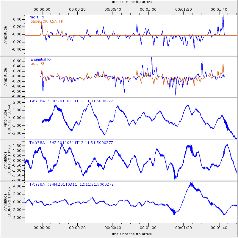
Y38A Idabel, OK, USA - Earthquake Result Viewer
*The percent match for this event was below the threshold and hence no stack was calculated.
| Earthquake location: |
Off East Coast Of Honshu, Japan |
| Earthquake latitude/longitude: |
35.8/142.1 |
| Earthquake time(UTC): |
2011/03/11 (070) 11:58:54 GMT |
| Earthquake Depth: |
35 km |
| Earthquake Magnitude: |
5.6 MB |
| Earthquake Catalog/Contributor: |
WHDF/NEIC |
|
| Network: |
TA USArray Transportable Network (new EarthScope stations) |
| Station: |
Y38A Idabel, OK, USA |
| Lat/Lon: |
33.93 N/94.73 W |
| Elevation: |
118 m |
|
| Distance: |
92.7 deg |
| Az: |
44.155 deg |
| Baz: |
317.041 deg |
| Ray Param: |
$rayparam |
*The percent match for this event was below the threshold and hence was not used in the summary stack. |
|
| Radial Match: |
51.418434 % |
| Radial Bump: |
311 |
| Transverse Match: |
68.37249 % |
| Transverse Bump: |
216 |
| SOD ConfigId: |
356183 |
| Insert Time: |
2011-08-15 23:44:49.882 +0000 |
| GWidth: |
2.5 |
| Max Bumps: |
400 |
| Tol: |
0.001 |
|
Signal To Noise
| Channel | StoN | STA | LTA |
| TA:Y38A: :BHZ:20110311T12:11:31.500027Z | 2.2622838 | 8.756081E-7 | 3.870461E-7 |
| TA:Y38A: :BHN:20110311T12:11:31.500027Z | 1.542652 | 5.6975546E-7 | 3.6933505E-7 |
| TA:Y38A: :BHE:20110311T12:11:31.500027Z | 1.2061644 | 1.0860207E-6 | 9.003919E-7 |
| Arrivals |
| Ps | |
| PpPs | |
| PsPs/PpSs | |


