You are here: Home > Network List > TA - USArray Transportable Network (new EarthScope stations) Stations List
> Station B05D Stanwood, WA, USA > Earthquake Result Viewer
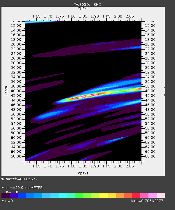
B05D Stanwood, WA, USA - Earthquake Result Viewer
| Earthquake location: |
Off East Coast Of Honshu, Japan |
| Earthquake latitude/longitude: |
35.8/142.1 |
| Earthquake time(UTC): |
2011/03/11 (070) 11:58:54 GMT |
| Earthquake Depth: |
35 km |
| Earthquake Magnitude: |
5.6 MB |
| Earthquake Catalog/Contributor: |
WHDF/NEIC |
|
| Network: |
TA USArray Transportable Network (new EarthScope stations) |
| Station: |
B05D Stanwood, WA, USA |
| Lat/Lon: |
48.26 N/122.10 W |
| Elevation: |
153 m |
|
| Distance: |
67.8 deg |
| Az: |
45.881 deg |
| Baz: |
299.083 deg |
| Ray Param: |
0.056656122 |
| Estimated Moho Depth: |
42.0 km |
| Estimated Crust Vp/Vs: |
1.86 |
| Assumed Crust Vp: |
6.566 km/s |
| Estimated Crust Vs: |
3.53 km/s |
| Estimated Crust Poisson's Ratio: |
0.30 |
|
| Radial Match: |
88.05677 % |
| Radial Bump: |
335 |
| Transverse Match: |
58.820564 % |
| Transverse Bump: |
262 |
| SOD ConfigId: |
356183 |
| Insert Time: |
2011-08-15 23:58:57.535 +0000 |
| GWidth: |
2.5 |
| Max Bumps: |
400 |
| Tol: |
0.001 |
|

Signal To Noise
| Channel | StoN | STA | LTA |
| TA:B05D: :BHZ:20110311T12:09:18.02499Z | 3.1874652 | 3.105298E-6 | 9.742217E-7 |
| TA:B05D: :BHN:20110311T12:09:18.02499Z | 1.6891346 | 1.9605445E-6 | 1.1606799E-6 |
| TA:B05D: :BHE:20110311T12:09:18.02499Z | 0.60416883 | 9.5004276E-7 | 1.5724789E-6 |
| Arrivals |
| Ps | 5.7 SECOND |
| PpPs | 18 SECOND |
| PsPs/PpSs | 23 SECOND |


