You are here: Home > Network List > TA - USArray Transportable Network (new EarthScope stations) Stations List
> Station D35A Remer, MN, USA > Earthquake Result Viewer
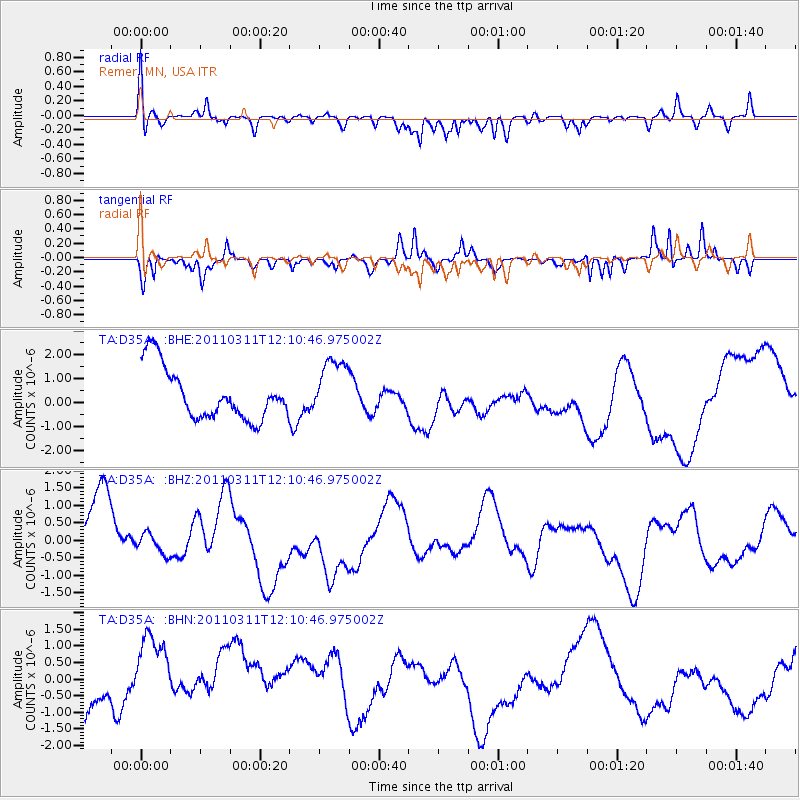
D35A Remer, MN, USA - Earthquake Result Viewer
*The percent match for this event was below the threshold and hence no stack was calculated.
| Earthquake location: |
Off East Coast Of Honshu, Japan |
| Earthquake latitude/longitude: |
35.8/142.1 |
| Earthquake time(UTC): |
2011/03/11 (070) 11:58:54 GMT |
| Earthquake Depth: |
35 km |
| Earthquake Magnitude: |
5.6 MB |
| Earthquake Catalog/Contributor: |
WHDF/NEIC |
|
| Network: |
TA USArray Transportable Network (new EarthScope stations) |
| Station: |
D35A Remer, MN, USA |
| Lat/Lon: |
47.08 N/94.05 W |
| Elevation: |
427 m |
|
| Distance: |
83.4 deg |
| Az: |
34.837 deg |
| Baz: |
317.164 deg |
| Ray Param: |
$rayparam |
*The percent match for this event was below the threshold and hence was not used in the summary stack. |
|
| Radial Match: |
48.31989 % |
| Radial Bump: |
382 |
| Transverse Match: |
76.03416 % |
| Transverse Bump: |
278 |
| SOD ConfigId: |
356183 |
| Insert Time: |
2011-08-16 00:00:39.171 +0000 |
| GWidth: |
2.5 |
| Max Bumps: |
400 |
| Tol: |
0.001 |
|
Signal To Noise
| Channel | StoN | STA | LTA |
| TA:D35A: :BHZ:20110311T12:10:46.975002Z | 0.3349645 | 3.0621342E-7 | 9.141667E-7 |
| TA:D35A: :BHN:20110311T12:10:46.975002Z | 1.3318907 | 1.5217977E-6 | 1.1425846E-6 |
| TA:D35A: :BHE:20110311T12:10:46.975002Z | 1.1601032 | 1.2301872E-6 | 1.0604118E-6 |
| Arrivals |
| Ps | |
| PpPs | |
| PsPs/PpSs | |


