You are here: Home > Network List > TA - USArray Transportable Network (new EarthScope stations) Stations List
> Station C38A Sawbill Landing (USFS), Superior Nat. Forest, MN, > Earthquake Result Viewer
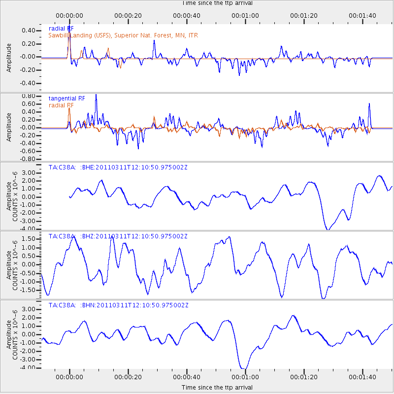
C38A Sawbill Landing (USFS), Superior Nat. Forest, MN, - Earthquake Result Viewer
*The percent match for this event was below the threshold and hence no stack was calculated.
| Earthquake location: |
Off East Coast Of Honshu, Japan |
| Earthquake latitude/longitude: |
35.8/142.1 |
| Earthquake time(UTC): |
2011/03/11 (070) 11:58:54 GMT |
| Earthquake Depth: |
35 km |
| Earthquake Magnitude: |
5.6 MB |
| Earthquake Catalog/Contributor: |
WHDF/NEIC |
|
| Network: |
TA USArray Transportable Network (new EarthScope stations) |
| Station: |
C38A Sawbill Landing (USFS), Superior Nat. Forest, MN, |
| Lat/Lon: |
47.72 N/91.27 W |
| Elevation: |
498 m |
|
| Distance: |
84.2 deg |
| Az: |
32.996 deg |
| Baz: |
319.005 deg |
| Ray Param: |
$rayparam |
*The percent match for this event was below the threshold and hence was not used in the summary stack. |
|
| Radial Match: |
46.330994 % |
| Radial Bump: |
292 |
| Transverse Match: |
73.602394 % |
| Transverse Bump: |
278 |
| SOD ConfigId: |
356183 |
| Insert Time: |
2011-08-16 00:03:02.892 +0000 |
| GWidth: |
2.5 |
| Max Bumps: |
400 |
| Tol: |
0.001 |
|
Signal To Noise
| Channel | StoN | STA | LTA |
| TA:C38A: :BHZ:20110311T12:10:50.975002Z | 1.7086632 | 1.5299518E-6 | 8.9540856E-7 |
| TA:C38A: :BHN:20110311T12:10:50.975002Z | 1.444188 | 1.0149078E-6 | 7.027532E-7 |
| TA:C38A: :BHE:20110311T12:10:50.975002Z | 0.7225108 | 6.3431355E-7 | 8.7792944E-7 |
| Arrivals |
| Ps | |
| PpPs | |
| PsPs/PpSs | |


