You are here: Home > Network List > UW - Pacific Northwest Regional Seismic Network Stations List
> Station MRBL Marblemount, WA, USA > Earthquake Result Viewer
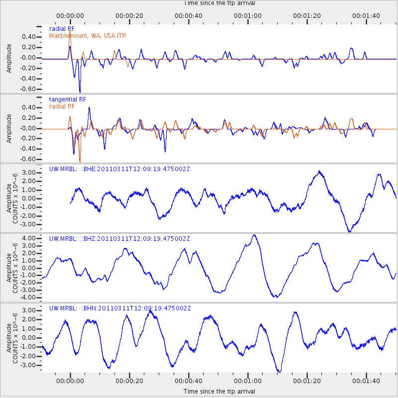
MRBL Marblemount, WA, USA - Earthquake Result Viewer
*The percent match for this event was below the threshold and hence no stack was calculated.
| Earthquake location: |
Off East Coast Of Honshu, Japan |
| Earthquake latitude/longitude: |
35.8/142.1 |
| Earthquake time(UTC): |
2011/03/11 (070) 11:58:54 GMT |
| Earthquake Depth: |
35 km |
| Earthquake Magnitude: |
5.6 MB |
| Earthquake Catalog/Contributor: |
WHDF/NEIC |
|
| Network: |
UW Pacific Northwest Regional Seismic Network |
| Station: |
MRBL Marblemount, WA, USA |
| Lat/Lon: |
48.52 N/121.48 W |
| Elevation: |
75 m |
|
| Distance: |
68.0 deg |
| Az: |
45.426 deg |
| Baz: |
299.368 deg |
| Ray Param: |
$rayparam |
*The percent match for this event was below the threshold and hence was not used in the summary stack. |
|
| Radial Match: |
86.61777 % |
| Radial Bump: |
400 |
| Transverse Match: |
46.552277 % |
| Transverse Bump: |
383 |
| SOD ConfigId: |
356183 |
| Insert Time: |
2011-08-16 00:24:50.290 +0000 |
| GWidth: |
2.5 |
| Max Bumps: |
400 |
| Tol: |
0.001 |
|
Signal To Noise
| Channel | StoN | STA | LTA |
| UW:MRBL: :BHZ:20110311T12:09:19.475002Z | 0.9577894 | 8.917331E-7 | 9.3103256E-7 |
| UW:MRBL: :BHN:20110311T12:09:19.475002Z | 0.9050306 | 1.1485803E-6 | 1.2691066E-6 |
| UW:MRBL: :BHE:20110311T12:09:19.475002Z | 2.8004808 | 1.7930317E-6 | 6.402585E-7 |
| Arrivals |
| Ps | |
| PpPs | |
| PsPs/PpSs | |


