You are here: Home > Network List > TA - USArray Transportable Network (new EarthScope stations) Stations List
> Station R11A Troy Canyon, Currant, NV, USA > Earthquake Result Viewer
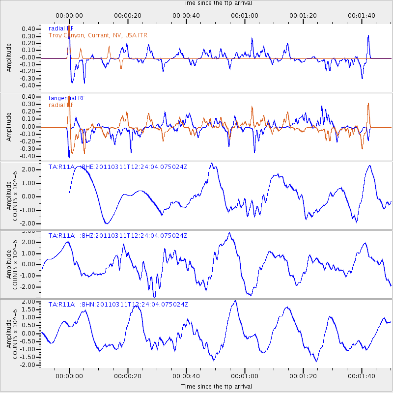
R11A Troy Canyon, Currant, NV, USA - Earthquake Result Viewer
*The percent match for this event was below the threshold and hence no stack was calculated.
| Earthquake location: |
Near East Coast Of Honshu, Japan |
| Earthquake latitude/longitude: |
38.1/142.5 |
| Earthquake time(UTC): |
2011/03/11 (070) 12:12:54 GMT |
| Earthquake Depth: |
35 km |
| Earthquake Magnitude: |
5.9 MB |
| Earthquake Catalog/Contributor: |
WHDF/NEIC |
|
| Network: |
TA USArray Transportable Network (new EarthScope stations) |
| Station: |
R11A Troy Canyon, Currant, NV, USA |
| Lat/Lon: |
38.35 N/115.59 W |
| Elevation: |
1756 m |
|
| Distance: |
75.4 deg |
| Az: |
52.66 deg |
| Baz: |
307.037 deg |
| Ray Param: |
$rayparam |
*The percent match for this event was below the threshold and hence was not used in the summary stack. |
|
| Radial Match: |
47.350372 % |
| Radial Bump: |
400 |
| Transverse Match: |
65.92775 % |
| Transverse Bump: |
380 |
| SOD ConfigId: |
356183 |
| Insert Time: |
2011-08-16 01:24:00.882 +0000 |
| GWidth: |
2.5 |
| Max Bumps: |
400 |
| Tol: |
0.001 |
|
Signal To Noise
| Channel | StoN | STA | LTA |
| TA:R11A: :BHZ:20110311T12:24:04.075024Z | 0.8977119 | 1.1137182E-6 | 1.2406188E-6 |
| TA:R11A: :BHN:20110311T12:24:04.075024Z | 0.8766635 | 1.4372407E-6 | 1.639444E-6 |
| TA:R11A: :BHE:20110311T12:24:04.075024Z | 0.93447113 | 1.1947993E-6 | 1.2785835E-6 |
| Arrivals |
| Ps | |
| PpPs | |
| PsPs/PpSs | |


