You are here: Home > Network List > TA - USArray Transportable Network (new EarthScope stations) Stations List
> Station A27A Ledoux Ranch, Antler, ND, USA > Earthquake Result Viewer
A27A Ledoux Ranch, Antler, ND, USA - Earthquake Result Viewer
| Earthquake location: |
Near East Coast Of Honshu, Japan |
| Earthquake latitude/longitude: |
38.1/142.5 |
| Earthquake time(UTC): |
2011/03/11 (070) 12:12:54 GMT |
| Earthquake Depth: |
35 km |
| Earthquake Magnitude: |
5.9 MB |
| Earthquake Catalog/Contributor: |
WHDF/NEIC |
|
| Network: |
TA USArray Transportable Network (new EarthScope stations) |
| Station: |
A27A Ledoux Ranch, Antler, ND, USA |
| Lat/Lon: |
48.95 N/101.24 W |
| Elevation: |
466 m |
|
| Distance: |
76.6 deg |
| Az: |
37.442 deg |
| Baz: |
313.275 deg |
| Ray Param: |
0.050835393 |
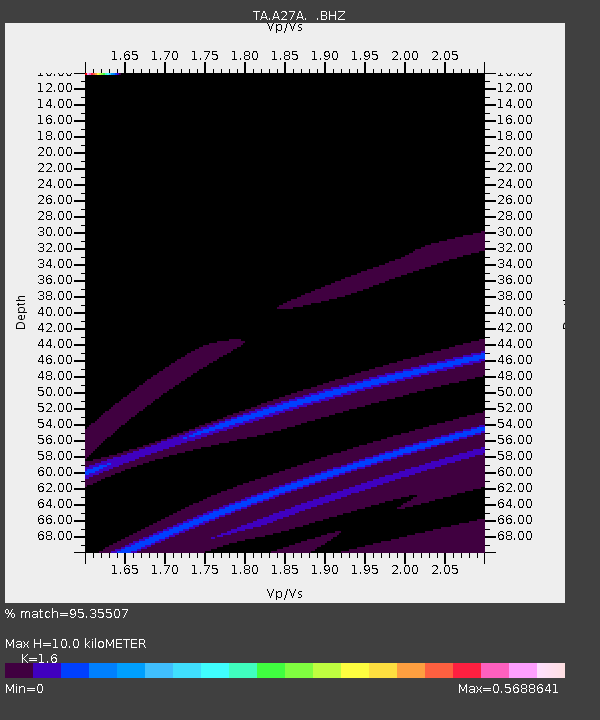
| Estimated Moho Depth: |
10.0 km |
| Estimated Crust Vp/Vs: |
1.60 |
| Assumed Crust Vp: |
6.438 km/s |
| Estimated Crust Vs: |
4.023 km/s |
| Estimated Crust Poisson's Ratio: |
0.18 |
|
| Radial Match: |
95.35507 % |
| Radial Bump: |
267 |
| Transverse Match: |
52.693367 % |
| Transverse Bump: |
400 |
| SOD ConfigId: |
356183 |
| Insert Time: |
2011-08-16 01:34:56.263 +0000 |
| GWidth: |
2.5 |
| Max Bumps: |
400 |
| Tol: |
0.001 |
|
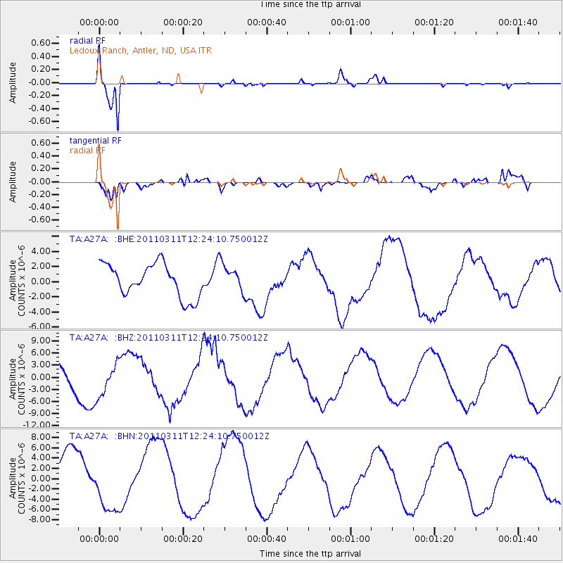
Signal To Noise
| Channel | StoN | STA | LTA |
| TA:A27A: :BHZ:20110311T12:24:10.750012Z | 1.1834227 | 4.292237E-6 | 3.6269687E-6 |
| TA:A27A: :BHN:20110311T12:24:10.750012Z | 1.3392315 | 5.383244E-6 | 4.0196514E-6 |
| TA:A27A: :BHE:20110311T12:24:10.750012Z | 0.76116544 | 1.6451888E-6 | 2.1614078E-6 |
| Arrivals |
| Ps | 1.0 SECOND |
| PpPs | 3.9 SECOND |
| PsPs/PpSs | 4.9 SECOND |


