You are here: Home > Network List > TA - USArray Transportable Network (new EarthScope stations) Stations List
> Station B28A Dugan Ranch, Towner, ND, USA > Earthquake Result Viewer
B28A Dugan Ranch, Towner, ND, USA - Earthquake Result Viewer
| Earthquake location: |
Near East Coast Of Honshu, Japan |
| Earthquake latitude/longitude: |
38.1/142.5 |
| Earthquake time(UTC): |
2011/03/11 (070) 12:12:54 GMT |
| Earthquake Depth: |
35 km |
| Earthquake Magnitude: |
5.9 MB |
| Earthquake Catalog/Contributor: |
WHDF/NEIC |
|
| Network: |
TA USArray Transportable Network (new EarthScope stations) |
| Station: |
B28A Dugan Ranch, Towner, ND, USA |
| Lat/Lon: |
48.45 N/100.36 W |
| Elevation: |
451 m |
|
| Distance: |
77.4 deg |
| Az: |
37.404 deg |
| Baz: |
313.925 deg |
| Ray Param: |
0.05031906 |
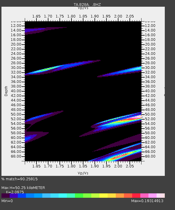
| Estimated Moho Depth: |
50.25 km |
| Estimated Crust Vp/Vs: |
2.10 |
| Assumed Crust Vp: |
6.438 km/s |
| Estimated Crust Vs: |
3.069 km/s |
| Estimated Crust Poisson's Ratio: |
0.35 |
|
| Radial Match: |
90.25915 % |
| Radial Bump: |
400 |
| Transverse Match: |
75.2916 % |
| Transverse Bump: |
400 |
| SOD ConfigId: |
356183 |
| Insert Time: |
2011-08-16 01:35:24.126 +0000 |
| GWidth: |
2.5 |
| Max Bumps: |
400 |
| Tol: |
0.001 |
|
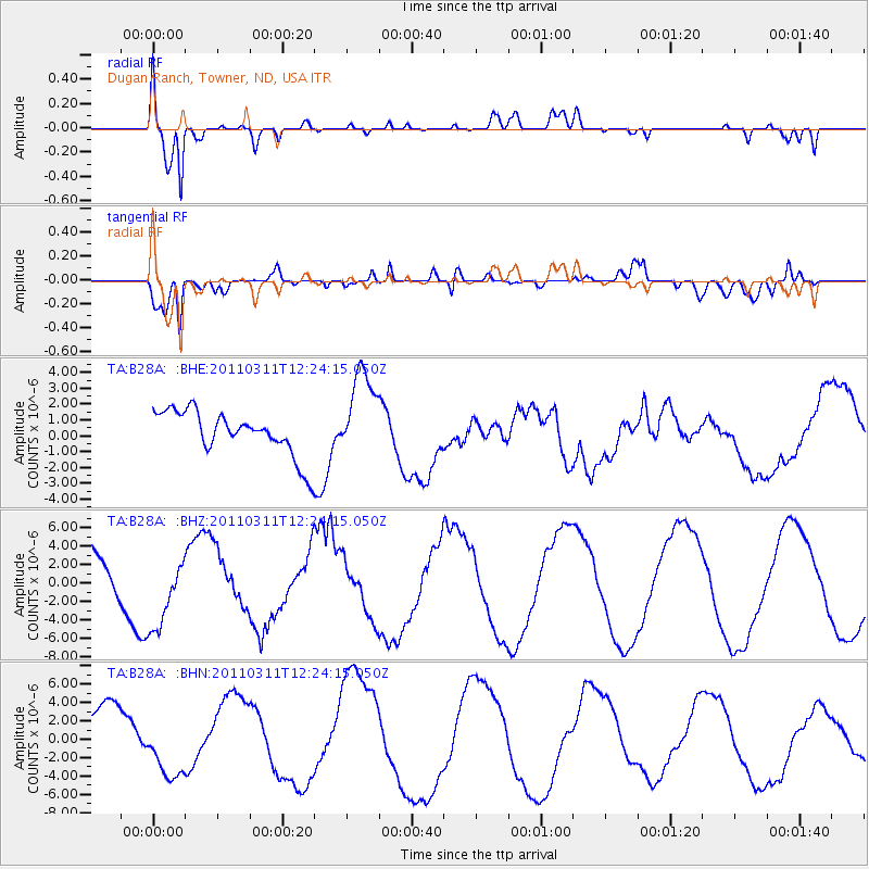
Signal To Noise
| Channel | StoN | STA | LTA |
| TA:B28A: :BHZ:20110311T12:24:15.050Z | 1.8303125 | 4.303262E-6 | 2.3511077E-6 |
| TA:B28A: :BHN:20110311T12:24:15.050Z | 1.1678404 | 3.122535E-6 | 2.6737684E-6 |
| TA:B28A: :BHE:20110311T12:24:15.050Z | 2.017495 | 2.8281115E-6 | 1.4017936E-6 |
| Arrivals |
| Ps | 8.8 SECOND |
| PpPs | 24 SECOND |
| PsPs/PpSs | 32 SECOND |


