You are here: Home > Network List > TA - USArray Transportable Network (new EarthScope stations) Stations List
> Station T33A Patterson Ranch, Waldron, KS, USA > Earthquake Result Viewer
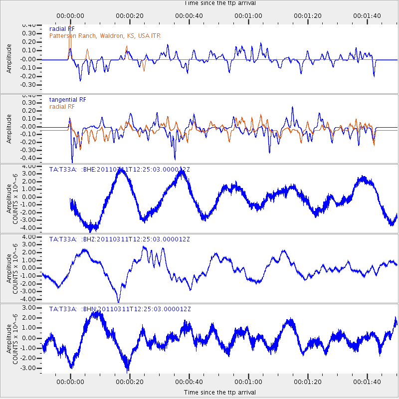
T33A Patterson Ranch, Waldron, KS, USA - Earthquake Result Viewer
*The percent match for this event was below the threshold and hence no stack was calculated.
| Earthquake location: |
Near East Coast Of Honshu, Japan |
| Earthquake latitude/longitude: |
38.1/142.5 |
| Earthquake time(UTC): |
2011/03/11 (070) 12:12:54 GMT |
| Earthquake Depth: |
35 km |
| Earthquake Magnitude: |
5.9 MB |
| Earthquake Catalog/Contributor: |
WHDF/NEIC |
|
| Network: |
TA USArray Transportable Network (new EarthScope stations) |
| Station: |
T33A Patterson Ranch, Waldron, KS, USA |
| Lat/Lon: |
37.08 N/98.24 W |
| Elevation: |
394 m |
|
| Distance: |
86.5 deg |
| Az: |
44.372 deg |
| Baz: |
316.345 deg |
| Ray Param: |
$rayparam |
*The percent match for this event was below the threshold and hence was not used in the summary stack. |
|
| Radial Match: |
53.077118 % |
| Radial Bump: |
400 |
| Transverse Match: |
48.948383 % |
| Transverse Bump: |
361 |
| SOD ConfigId: |
356183 |
| Insert Time: |
2011-08-16 01:38:51.725 +0000 |
| GWidth: |
2.5 |
| Max Bumps: |
400 |
| Tol: |
0.001 |
|
Signal To Noise
| Channel | StoN | STA | LTA |
| TA:T33A: :BHZ:20110311T12:25:03.000012Z | 1.2587126 | 1.3197359E-6 | 1.0484807E-6 |
| TA:T33A: :BHN:20110311T12:25:03.000012Z | 2.4360075 | 2.2207162E-6 | 9.116212E-7 |
| TA:T33A: :BHE:20110311T12:25:03.000012Z | 0.6555499 | 1.6094706E-6 | 2.455146E-6 |
| Arrivals |
| Ps | |
| PpPs | |
| PsPs/PpSs | |


