You are here: Home > Network List > TA - USArray Transportable Network (new EarthScope stations) Stations List
> Station J05D Fort Rock, OR, USA > Earthquake Result Viewer
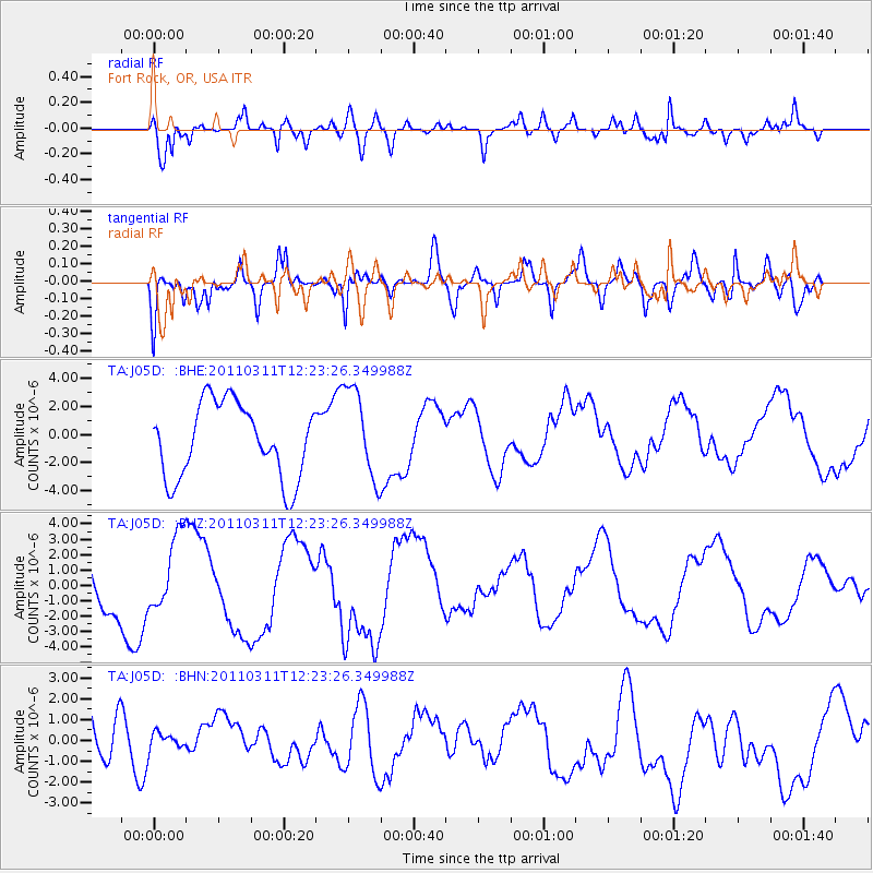
J05D Fort Rock, OR, USA - Earthquake Result Viewer
*The percent match for this event was below the threshold and hence no stack was calculated.
| Earthquake location: |
Near East Coast Of Honshu, Japan |
| Earthquake latitude/longitude: |
38.1/142.5 |
| Earthquake time(UTC): |
2011/03/11 (070) 12:12:54 GMT |
| Earthquake Depth: |
35 km |
| Earthquake Magnitude: |
5.9 MB |
| Earthquake Catalog/Contributor: |
WHDF/NEIC |
|
| Network: |
TA USArray Transportable Network (new EarthScope stations) |
| Station: |
J05D Fort Rock, OR, USA |
| Lat/Lon: |
43.28 N/121.23 W |
| Elevation: |
1541 m |
|
| Distance: |
69.1 deg |
| Az: |
51.0 deg |
| Baz: |
302.847 deg |
| Ray Param: |
$rayparam |
*The percent match for this event was below the threshold and hence was not used in the summary stack. |
|
| Radial Match: |
77.81754 % |
| Radial Bump: |
372 |
| Transverse Match: |
54.54945 % |
| Transverse Bump: |
400 |
| SOD ConfigId: |
356183 |
| Insert Time: |
2011-08-16 01:39:10.883 +0000 |
| GWidth: |
2.5 |
| Max Bumps: |
400 |
| Tol: |
0.001 |
|
Signal To Noise
| Channel | StoN | STA | LTA |
| TA:J05D: :BHZ:20110311T12:23:26.349988Z | 1.0836676 | 2.2900065E-6 | 2.1131998E-6 |
| TA:J05D: :BHN:20110311T12:23:26.349988Z | 0.32367754 | 4.0103782E-7 | 1.2390042E-6 |
| TA:J05D: :BHE:20110311T12:23:26.349988Z | 1.2238078 | 3.2561213E-6 | 2.6606476E-6 |
| Arrivals |
| Ps | |
| PpPs | |
| PsPs/PpSs | |


