You are here: Home > Network List > TA - USArray Transportable Network (new EarthScope stations) Stations List
> Station Q36A Arnold C. Orvedal, Lecompton, KS, USA > Earthquake Result Viewer
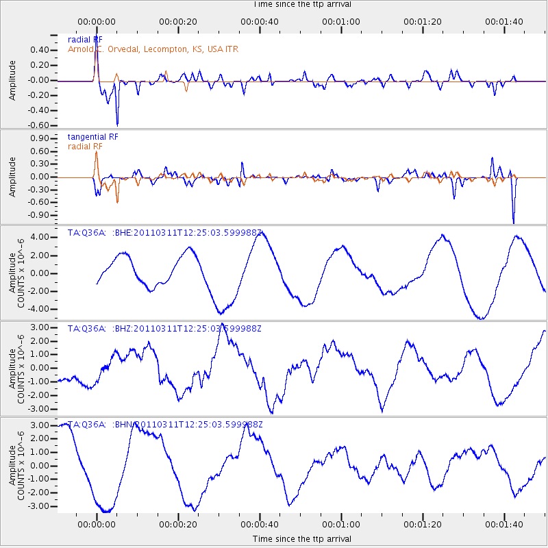
Q36A Arnold C. Orvedal, Lecompton, KS, USA - Earthquake Result Viewer

| Earthquake location: |
Near East Coast Of Honshu, Japan |
| Earthquake latitude/longitude: |
38.1/142.5 |
| Earthquake time(UTC): |
2011/03/11 (070) 12:12:54 GMT |
| Earthquake Depth: |
35 km |
| Earthquake Magnitude: |
5.9 MB |
| Earthquake Catalog/Contributor: |
WHDF/NEIC |
|
| Network: |
TA USArray Transportable Network (new EarthScope stations) |
| Station: |
Q36A Arnold C. Orvedal, Lecompton, KS, USA |
| Lat/Lon: |
38.96 N/95.46 W |
| Elevation: |
306 m |
|
| Distance: |
86.7 deg |
| Az: |
41.48 deg |
| Baz: |
317.881 deg |
| Ray Param: |
0.043847304 |
| Estimated Moho Depth: |
50.5 km |
| Estimated Crust Vp/Vs: |
1.82 |
| Assumed Crust Vp: |
6.498 km/s |
| Estimated Crust Vs: |
3.565 km/s |
| Estimated Crust Poisson's Ratio: |
0.28 |
|
| Radial Match: |
86.25747 % |
| Radial Bump: |
365 |
| Transverse Match: |
60.632427 % |
| Transverse Bump: |
283 |
| SOD ConfigId: |
356183 |
| Insert Time: |
2011-08-16 01:50:09.290 +0000 |
| GWidth: |
2.5 |
| Max Bumps: |
400 |
| Tol: |
0.001 |
|
Signal To Noise
| Channel | StoN | STA | LTA |
| TA:Q36A: :BHZ:20110311T12:25:03.599988Z | 0.6820133 | 9.774224E-7 | 1.4331428E-6 |
| TA:Q36A: :BHN:20110311T12:25:03.599988Z | 1.6731576 | 3.5080345E-6 | 2.0966552E-6 |
| TA:Q36A: :BHE:20110311T12:25:03.599988Z | 2.7782757 | 4.1516587E-6 | 1.4943292E-6 |
| Arrivals |
| Ps | 6.5 SECOND |
| PpPs | 21 SECOND |
| PsPs/PpSs | 28 SECOND |


