You are here: Home > Network List > TA - USArray Transportable Network (new EarthScope stations) Stations List
> Station H04D Lebanon, OR, USA > Earthquake Result Viewer
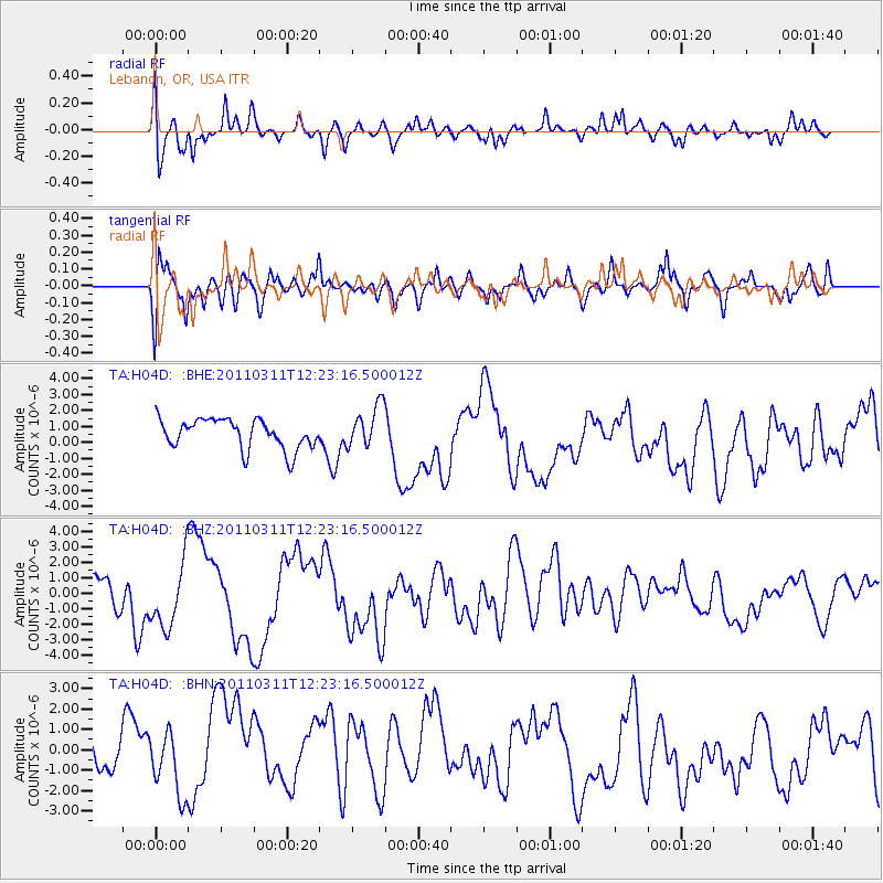
H04D Lebanon, OR, USA - Earthquake Result Viewer
*The percent match for this event was below the threshold and hence no stack was calculated.
| Earthquake location: |
Near East Coast Of Honshu, Japan |
| Earthquake latitude/longitude: |
38.1/142.5 |
| Earthquake time(UTC): |
2011/03/11 (070) 12:12:54 GMT |
| Earthquake Depth: |
35 km |
| Earthquake Magnitude: |
5.9 MB |
| Earthquake Catalog/Contributor: |
WHDF/NEIC |
|
| Network: |
TA USArray Transportable Network (new EarthScope stations) |
| Station: |
H04D Lebanon, OR, USA |
| Lat/Lon: |
44.52 N/122.74 W |
| Elevation: |
284 m |
|
| Distance: |
67.5 deg |
| Az: |
50.496 deg |
| Baz: |
301.622 deg |
| Ray Param: |
$rayparam |
*The percent match for this event was below the threshold and hence was not used in the summary stack. |
|
| Radial Match: |
58.718952 % |
| Radial Bump: |
400 |
| Transverse Match: |
51.87188 % |
| Transverse Bump: |
400 |
| SOD ConfigId: |
356183 |
| Insert Time: |
2011-08-16 01:54:27.286 +0000 |
| GWidth: |
2.5 |
| Max Bumps: |
400 |
| Tol: |
0.001 |
|
Signal To Noise
| Channel | StoN | STA | LTA |
| TA:H04D: :BHZ:20110311T12:23:16.500012Z | 1.8921585 | 2.653727E-6 | 1.4024866E-6 |
| TA:H04D: :BHN:20110311T12:23:16.500012Z | 1.4207772 | 1.4342698E-6 | 1.0094967E-6 |
| TA:H04D: :BHE:20110311T12:23:16.500012Z | 1.4135413 | 1.3198904E-6 | 9.337474E-7 |
| Arrivals |
| Ps | |
| PpPs | |
| PsPs/PpSs | |


