You are here: Home > Network List > TA - USArray Transportable Network (new EarthScope stations) Stations List
> Station E33A Westby DABS, Erhard, MN, USA > Earthquake Result Viewer
E33A Westby DABS, Erhard, MN, USA - Earthquake Result Viewer
| Earthquake location: |
Near East Coast Of Honshu, Japan |
| Earthquake latitude/longitude: |
38.1/142.5 |
| Earthquake time(UTC): |
2011/03/11 (070) 12:12:54 GMT |
| Earthquake Depth: |
35 km |
| Earthquake Magnitude: |
5.9 MB |
| Earthquake Catalog/Contributor: |
WHDF/NEIC |
|
| Network: |
TA USArray Transportable Network (new EarthScope stations) |
| Station: |
E33A Westby DABS, Erhard, MN, USA |
| Lat/Lon: |
46.50 N/96.01 W |
| Elevation: |
428 m |
|
| Distance: |
80.8 deg |
| Az: |
36.65 deg |
| Baz: |
316.984 deg |
| Ray Param: |
0.04796414 |
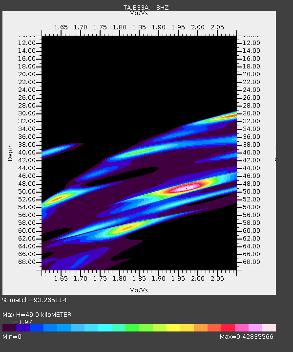
| Estimated Moho Depth: |
49.0 km |
| Estimated Crust Vp/Vs: |
1.97 |
| Assumed Crust Vp: |
6.498 km/s |
| Estimated Crust Vs: |
3.298 km/s |
| Estimated Crust Poisson's Ratio: |
0.33 |
|
| Radial Match: |
93.265114 % |
| Radial Bump: |
400 |
| Transverse Match: |
22.620712 % |
| Transverse Bump: |
221 |
| SOD ConfigId: |
356183 |
| Insert Time: |
2011-08-16 01:55:22.314 +0000 |
| GWidth: |
2.5 |
| Max Bumps: |
400 |
| Tol: |
0.001 |
|
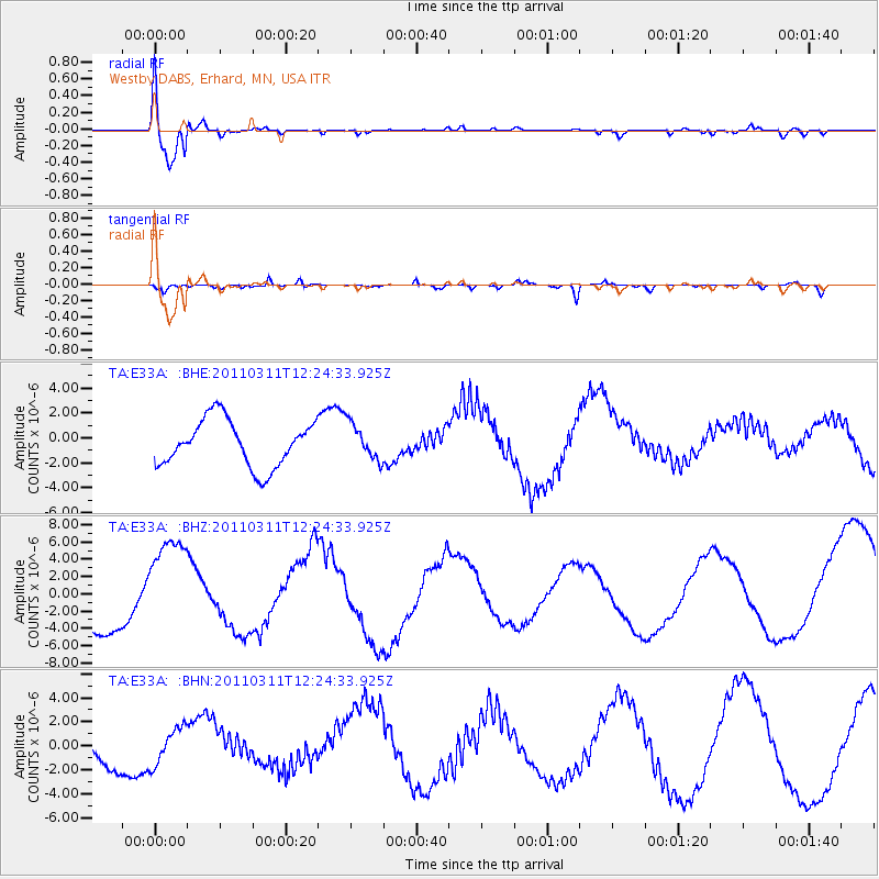
Signal To Noise
| Channel | StoN | STA | LTA |
| TA:E33A: :BHZ:20110311T12:24:33.925Z | 2.2233796 | 6.2898057E-6 | 2.8289392E-6 |
| TA:E33A: :BHN:20110311T12:24:33.925Z | 1.7506015 | 1.6056316E-6 | 9.1718846E-7 |
| TA:E33A: :BHE:20110311T12:24:33.925Z | 0.7785109 | 1.4549914E-6 | 1.8689415E-6 |
| Arrivals |
| Ps | 7.5 SECOND |
| PpPs | 22 SECOND |
| PsPs/PpSs | 29 SECOND |


