You are here: Home > Network List > US - United States National Seismic Network Stations List
> Station MNTX Cornudas Mountains, Texas, USA > Earthquake Result Viewer
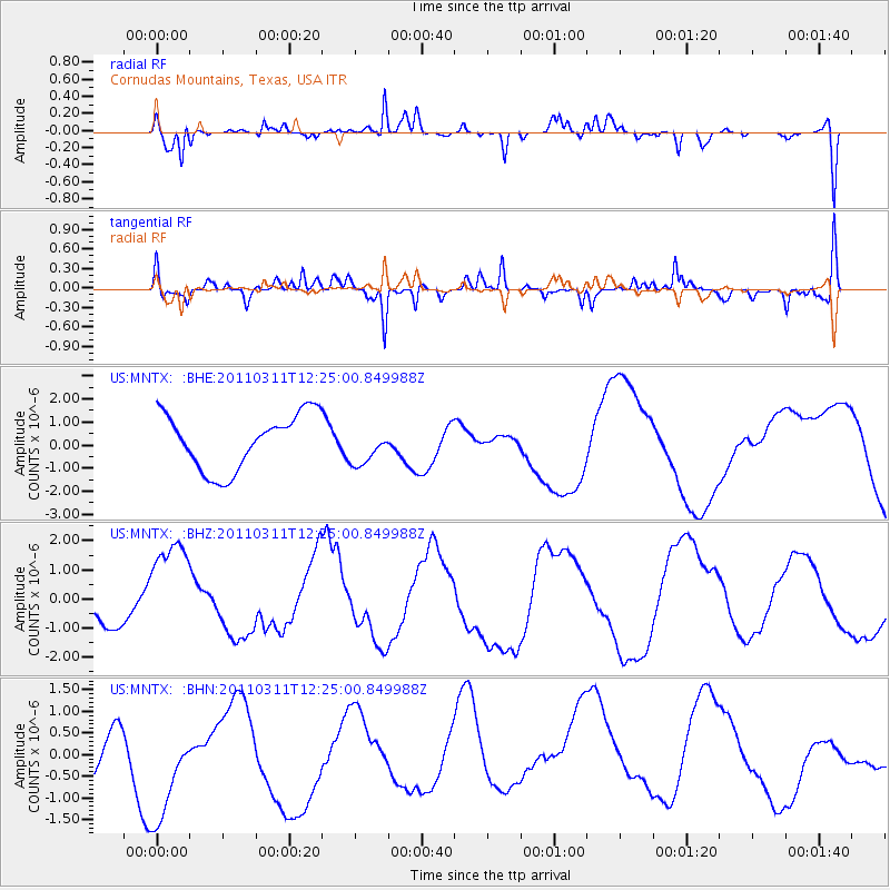
MNTX Cornudas Mountains, Texas, USA - Earthquake Result Viewer
*The percent match for this event was below the threshold and hence no stack was calculated.
| Earthquake location: |
Near East Coast Of Honshu, Japan |
| Earthquake latitude/longitude: |
38.1/142.5 |
| Earthquake time(UTC): |
2011/03/11 (070) 12:12:54 GMT |
| Earthquake Depth: |
35 km |
| Earthquake Magnitude: |
5.9 MB |
| Earthquake Catalog/Contributor: |
WHDF/NEIC |
|
| Network: |
US United States National Seismic Network |
| Station: |
MNTX Cornudas Mountains, Texas, USA |
| Lat/Lon: |
31.70 N/105.38 W |
| Elevation: |
404 m |
|
| Distance: |
86.1 deg |
| Az: |
52.352 deg |
| Baz: |
312.838 deg |
| Ray Param: |
$rayparam |
*The percent match for this event was below the threshold and hence was not used in the summary stack. |
|
| Radial Match: |
73.58097 % |
| Radial Bump: |
326 |
| Transverse Match: |
71.24736 % |
| Transverse Bump: |
370 |
| SOD ConfigId: |
356183 |
| Insert Time: |
2011-08-16 02:19:16.378 +0000 |
| GWidth: |
2.5 |
| Max Bumps: |
400 |
| Tol: |
0.001 |
|
Signal To Noise
| Channel | StoN | STA | LTA |
| US:MNTX: :BHZ:20110311T12:25:00.849988Z | 2.1593122 | 1.7919383E-6 | 8.2986526E-7 |
| US:MNTX: :BHN:20110311T12:25:00.849988Z | 2.1375434 | 1.5759132E-6 | 7.3725437E-7 |
| US:MNTX: :BHE:20110311T12:25:00.849988Z | 0.67344123 | 8.07685E-7 | 1.19934E-6 |
| Arrivals |
| Ps | |
| PpPs | |
| PsPs/PpSs | |


