You are here: Home > Network List > MN - MEDNET Project Stations List
> Station WDD Wield Dalam, Malta > Earthquake Result Viewer
WDD Wield Dalam, Malta - Earthquake Result Viewer
| Earthquake location: |
Near East Coast Of Honshu, Japan |
| Earthquake latitude/longitude: |
39.1/142.3 |
| Earthquake time(UTC): |
2011/03/11 (070) 12:15:45 GMT |
| Earthquake Depth: |
50 km |
| Earthquake Magnitude: |
5.8 MB |
| Earthquake Catalog/Contributor: |
WHDF/NEIC |
|
| Network: |
MN MEDNET Project |
| Station: |
WDD Wield Dalam, Malta |
| Lat/Lon: |
35.87 N/14.52 E |
| Elevation: |
41 m |
|
| Distance: |
91.2 deg |
| Az: |
320.026 deg |
| Baz: |
37.995 deg |
| Ray Param: |
0.041612297 |
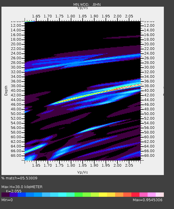
| Estimated Moho Depth: |
38.0 km |
| Estimated Crust Vp/Vs: |
2.06 |
| Assumed Crust Vp: |
4.05 km/s |
| Estimated Crust Vs: |
1.971 km/s |
| Estimated Crust Poisson's Ratio: |
0.34 |
|
| Radial Match: |
85.53809 % |
| Radial Bump: |
400 |
| Transverse Match: |
67.10336 % |
| Transverse Bump: |
400 |
| SOD ConfigId: |
356183 |
| Insert Time: |
2011-08-16 03:25:06.194 +0000 |
| GWidth: |
2.5 |
| Max Bumps: |
400 |
| Tol: |
0.001 |
|
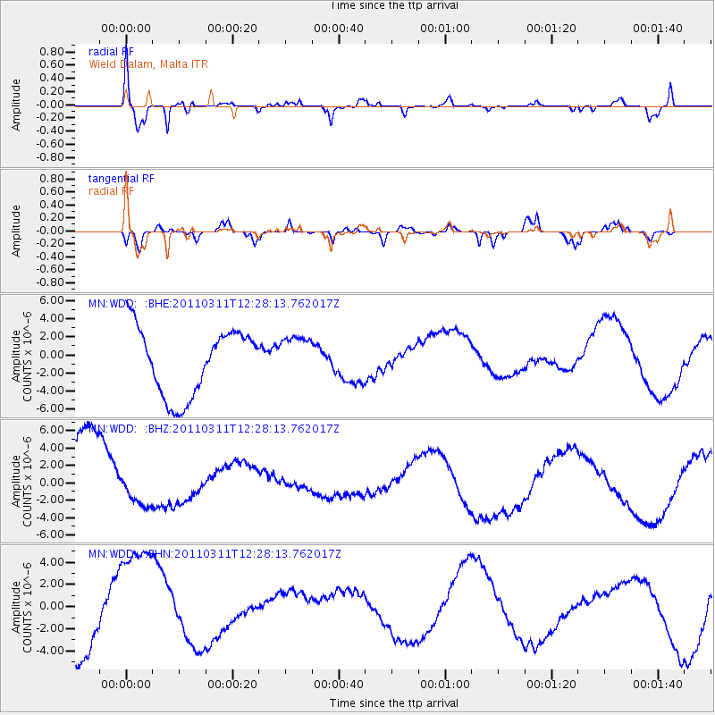
Signal To Noise
| Channel | StoN | STA | LTA |
| MN:WDD: :BHZ:20110311T12:28:13.762017Z | 0.21476613 | 1.0861526E-6 | 5.057374E-6 |
| MN:WDD: :BHN:20110311T12:28:13.762017Z | 1.5924884 | 5.28503E-6 | 3.3187243E-6 |
| MN:WDD: :BHE:20110311T12:28:13.762017Z | 0.65482 | 2.424171E-6 | 3.7020416E-6 |
| Arrivals |
| Ps | 10.0 SECOND |
| PpPs | 28 SECOND |
| PsPs/PpSs | 38 SECOND |


