You are here: Home > Network List > TA - USArray Transportable Network (new EarthScope stations) Stations List
> Station E25A Miller Ranch, Amidon, ND, USA > Earthquake Result Viewer
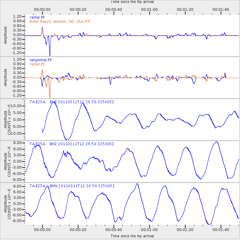
E25A Miller Ranch, Amidon, ND, USA - Earthquake Result Viewer
*The percent match for this event was below the threshold and hence no stack was calculated.
| Earthquake location: |
Near East Coast Of Honshu, Japan |
| Earthquake latitude/longitude: |
39.1/142.3 |
| Earthquake time(UTC): |
2011/03/11 (070) 12:15:45 GMT |
| Earthquake Depth: |
50 km |
| Earthquake Magnitude: |
5.8 MB |
| Earthquake Catalog/Contributor: |
WHDF/NEIC |
|
| Network: |
TA USArray Transportable Network (new EarthScope stations) |
| Station: |
E25A Miller Ranch, Amidon, ND, USA |
| Lat/Lon: |
46.50 N/103.40 W |
| Elevation: |
885 m |
|
| Distance: |
76.6 deg |
| Az: |
40.326 deg |
| Baz: |
313.187 deg |
| Ray Param: |
$rayparam |
*The percent match for this event was below the threshold and hence was not used in the summary stack. |
|
| Radial Match: |
94.48948 % |
| Radial Bump: |
400 |
| Transverse Match: |
70.30127 % |
| Transverse Bump: |
400 |
| SOD ConfigId: |
356183 |
| Insert Time: |
2011-08-16 03:43:58.553 +0000 |
| GWidth: |
2.5 |
| Max Bumps: |
400 |
| Tol: |
0.001 |
|
Signal To Noise
| Channel | StoN | STA | LTA |
| TA:E25A: :BHZ:20110311T12:26:59.325005Z | 1.0002828 | 4.5394845E-6 | 4.538201E-6 |
| TA:E25A: :BHN:20110311T12:26:59.325005Z | 2.1222599 | 7.4697496E-6 | 3.5197147E-6 |
| TA:E25A: :BHE:20110311T12:26:59.325005Z | 0.6847636 | 6.2608183E-6 | 9.143036E-6 |
| Arrivals |
| Ps | |
| PpPs | |
| PsPs/PpSs | |


