You are here: Home > Network List > TA - USArray Transportable Network (new EarthScope stations) Stations List
> Station G29A Hoven, SD, USA > Earthquake Result Viewer
G29A Hoven, SD, USA - Earthquake Result Viewer
| Earthquake location: |
Near East Coast Of Honshu, Japan |
| Earthquake latitude/longitude: |
39.1/142.3 |
| Earthquake time(UTC): |
2011/03/11 (070) 12:15:45 GMT |
| Earthquake Depth: |
50 km |
| Earthquake Magnitude: |
5.8 MB |
| Earthquake Catalog/Contributor: |
WHDF/NEIC |
|
| Network: |
TA USArray Transportable Network (new EarthScope stations) |
| Station: |
G29A Hoven, SD, USA |
| Lat/Lon: |
45.19 N/99.92 W |
| Elevation: |
588 m |
|
| Distance: |
79.2 deg |
| Az: |
39.544 deg |
| Baz: |
315.511 deg |
| Ray Param: |
0.04902712 |
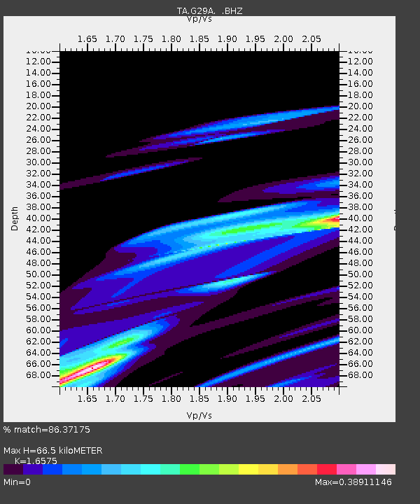
| Estimated Moho Depth: |
66.5 km |
| Estimated Crust Vp/Vs: |
1.66 |
| Assumed Crust Vp: |
6.53 km/s |
| Estimated Crust Vs: |
3.94 km/s |
| Estimated Crust Poisson's Ratio: |
0.21 |
|
| Radial Match: |
86.37175 % |
| Radial Bump: |
400 |
| Transverse Match: |
69.67528 % |
| Transverse Bump: |
400 |
| SOD ConfigId: |
356183 |
| Insert Time: |
2011-08-16 03:51:07.844 +0000 |
| GWidth: |
2.5 |
| Max Bumps: |
400 |
| Tol: |
0.001 |
|

Signal To Noise
| Channel | StoN | STA | LTA |
| TA:G29A: :BHZ:20110311T12:27:13.999993Z | 1.8361689 | 7.4195555E-6 | 4.040781E-6 |
| TA:G29A: :BHN:20110311T12:27:13.999993Z | 1.0283521 | 2.912328E-6 | 2.8320337E-6 |
| TA:G29A: :BHE:20110311T12:27:13.999993Z | 0.74227244 | 1.5019118E-6 | 2.023397E-6 |
| Arrivals |
| Ps | 6.9 SECOND |
| PpPs | 26 SECOND |
| PsPs/PpSs | 33 SECOND |


